The products offered by the Hydroweb project consist of continuous, long-duration time-series of the levels of large lakes with surface areas over 100 km2, reservoirs and the 20 biggest rivers in the world.
The operational measurement series are updated no later than 1.5 days after a new altimetry measurement becomes available. They cover about 80 large lakes and 300 measurement points along about 20 major rivers.
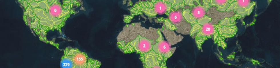
The research measurement series are updated at regular intervals according to the progress made with processing by the LEGOS laboratory. They cover about 150 large lakes and 1,000 measurement points along about 20 major rivers.
Continental waters account for only 0.65% of the total amount of water on Earth, 97% being stored in the oceans and 2.15% in the cryosphere. However, these waters have a significant impact on life on Earth and household needs. They also play a major role in climate variability. Water on Earth is continually recycled through precipitation, evaporation and run-off towards the sea. The increasingly accurate characterisation of the water cycle on land surfaces enables more accurate forecasting of the climate and more careful control of global water resources (human consumption and activities such as agriculture, urbanisation and the production of hydroelectric power, for example).
Satellite altimetry is used to measure the water level of rivers, lakes and flooded plains. Since the early 1990s, various altimetry satellites have been launched: ERS-1 (1991-1996), Topex/Poseidon (1992-2006), ERS-2 (1995-2011), GFO (2000- ), Jason-1 (2001-2013), Envisat (2002-2012), Jason-2 (2008- ) and Saral/Altika (2013- ). Their main goal is to measure sea surface height, but their altimetry measurements can also be used to measure the level of continental waters (inland seas, rivers, lakes, wetlands and reservoirs).
These observations are used to compile long time series of continental water surface levels. The products are a significant complement and may even be an alternative to in situ measurements, particularly in regions where there are either no ground measurement networks or where they are gradually disappearing. When used alongside other hydrological data and output from hydrological models, these data make a significant contribution to studies of the water cycle and the quantification of water resources.
The processed data from future altimetry satellites Sentinel-3A/3B, Jason-3 (July 2015- ), Jason-CS and SWOT will ensure the continuity of this time series.
In the framework of Theia, CNES has developed a ground segment for producing and disseminating surface level measurements for continental waters. The HYSOPE operational satellite hydrometry ground segment is based on the global database gathering together time series of water levels along with the processing algorithms developed by the LEGOS laboratory for the Hydroweb project.
HYSOPE is run by CLS on behalf of CNES.