Theia’s first Sentinel-2 Level 2A data available over France
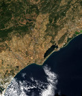
A first large scale data set of Sentinel-2 level 2A products was just issued by CNES. It contains all the data acquired by Sentinel-2 over France, from December 1st, 2015 until end of August. It was produced with MACCS on MUSCATE ground segment. The data can be downloaded from http://theia.cnes.fr
All you need to do is register, log in, and then search and download. You may use classical requests with criteria or much simpler ones such as « Toulouse in July ». You may also use the tile number to select the data set, for instance « T31TEJ » for Montpellier (don’t forget the first T). There is also a python program to automatically download the data. The data format is described here.
For more information, see http://www.cesbio.ups-tlse.fr