

Presentation
Theia Colours of the Continental Waters Scientific Expertise Center (SEC) was created in 2015 in order to federate the French scientific and technical communities working on issues related to satellite remote sensing and the monitoring of water quality in rivers, lakes and estuaries.
In coordination with CNES, Theia Colours of the Continental Waters SEC is currently led by teams from the Toulouse Geosciences Laboratory (GET/Institute of Research for Development) and the ECLA (ÉCosystèmes LAcustres) cluster, which includes the French Office for Biodiversity (OFB), the National Research Institute for Agriculture, Food and the Environment (INRAE) and the University of Savoie Mont-Blanc (USMB). The objective of Theia SEC is to contribute to the development and validation of high-resolution (Landsat and Sentinel-2) and low-resolution (MODIS, VIIRS, Sentinel-3) satellite products for estimating quality parameters related to water colour (e.g. transparency, turbidity, concentrations of suspended matter, dissolved organic matter, chlorophyll-a, etc.). To do so, it adopts an approach that combines field, modelling and satellite by relying on multiple sites in France and in tropical environments.
The SEC teams are renowned nationally and internationally for their command of the various aspects of remote sensing of the colour of continental waters. In particular, they have developed the GRS (Glint Removal for Sentinel-2) algorithm (Harmel et al., 2018), which corrects for atmospheric effects (molecules and aerosols) and sunlight reflection on the water surface (glint), the WaterDetect algorithm for automated and robust detection of water surfaces (Cordeiro et al., 2021), and the modelling of water colour signals in the context of inland waters (Pinet et al., 2017).
The SEC is also interested in the integration of ‘water colour’ satellite products into ecological and hydrological studies for the measurement of sediment fluxes (Espinoza-Villar et al., 2018; Yepez et al., 2018), reservoir siltation (Condé et al., 2019), the monitoring of lake euthrophication (Lins et al., 2017) or the monitoring of the impact of gold mining activities (Gallay et al., 2018).
The SEC is also working to build a database of in-situ optical properties representative of the different types of colour (TELQUEL and GET database). These measurements are essential for evaluating the performance of the algorithms.
A characteristic effort of the group is to propose operational processing chains for the production of these parameters either by CNES on demonstration sites or by the OFB on lakes monitored in particular within the framework of the European Water Framework Directive in France (including the DROM). The products generated are (or will be) freely available on ad-hoc distribution platforms (Hydroweb.Next for CNES and geoECLA for ECLA). Today, the GRS, WaterDetect and SISPPEO (Satellite Imagery & Signal Processing Packages for Earth Observation) software are operational. Two chains have been sent to CNES to calculate the satellite signal in terms of ecological quality parameters from these software packages:
- (i) a V1 chain that produces level 3 images from level 2 Sentinel-2 satellite images provided by the MAJA chain;
- (ii) a V2 chain that produces level 3 images from level 1C Sentinel-2 images and specifically corrected by the GRS module.
Previously, the MOD3R chain, developed at GET for processing MODIS satellite images, was transferred to the Brazilian Water Agency (ANA – http://hidrosat.ana.gov.br/) (Martinez et al. 2015)
Specific objectives
- Demonstrate the technical feasibility of monitoring water quality parameters (concentration of suspended solids, chlorophyll-a, turbidity) in lakes and rivers by satellite by working on instrumented observation sites that allow precise validation of space-based products by conventional measurements;
- Develop knowledge of the inland water optical properties by carrying out radiometric measurement campaigns at numerous sites in order to establish robust inversion algorithms and test radiometric models from the literature;
- Use optical modelling to study the variability of the inherent optical properties in relation to the physico-chemical characteristics of the water measured in situ, such as the characteristics of suspended matter (particle-size distribution, mineralogy) or the vertical distribution of phytoplankton in the water column;
- Exploiting time series of high-resolution Sentinel-2, Landsat and low-resolution satellite images (MODIS, VIIRS, Sentinel-3) in order to carry out thematic studies related to environmental changes in France and worldwide.
- To propose a multiscale approach by considering all remote sensing techniques including field monitoring, drones and satellite data.
Completed and ongoing projects
The various research projects in this SEC are funded by a wide panel of institutions, including CNES and OFB in France. The group has also obtained funding from the European Commission for the promotion of Sentinel data, by organizing summer schools on the colour of continental waters opened to researchers and managers from all over the world in 2022 and 2023. A PhD thesis dedicated to black water (rich in dissolved organic carbon), co-financed by the French Guiana Water Office, EDF France and the OFB, has started in 2021. More than 20 PhD has been realized since 2009 to develop the use of water colour data for inland water quality mapping.
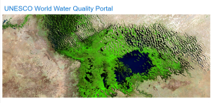
It should be noted that the SEC teams have been chosen by UNESCO to develop the World Water Quality Portal on Lake Chad in conjunction with the Lake Chad Basin Commission in order to monitor several water-quality parameters using Sentinel-2 and Landsat-8 imagery (https://en.unesco.org/waterqualitymonitor). This portal also offers water surface temperature estimated from thermal infrared Landsat imagery produced by the ECLA cluster.
Completed projects
The OBS2CO project (2018-2020, CNES-TOSCA, UMR GET / Pôle ECLA) contributed to the development of the use of satellite remote-sensing for monitoring the quality of water in rivers, lakes and estuaries by proposing a multi-site approach (in France and in the South). It has enabled the development of an automated “water colour” processing chain for Sentinel-2 and Landsat-8 products on continental waters, which has been progressively transferred to the Theia platform and HYSOPE-II (satellite data platform dedicated to the hydrosystem theme).
The HIDROSAT project with the Brazilian Water Agency, the Institute of Research for Development and numerous academic and institutional partners in Brazil since 2010 to develop a server making freely available information on water quality obtained by satellite (MODIS imagery) and to validate the products obtained in the context of a pre-operational use by a major water resource management agency. A new phase of the project starts in 2021.
The HYDROSIM project (2018-2021), funded by the BPI and the Aerospace Valley and Water clusters, to develop the integrated use of conventional measurement networks, products from space hydrology and hydrological and water quality modelling in the Amazon basin.
Ongoing projects
The Space Climate Observatory XTREM-QUALITY project originates from the SEC technical and scientific production, aiming at delivering regional trends on water quality variability in reservoirs located in agricultural areas. It starts in 2023 and is funded by CNES and the Regional Water Agency “Adour Garonne”. (https://www.spaceclimateobservatory.org/xtremquality-france).
The OBS2MOD project (2021-2023, CNES-TOSCA UMR GET / Pôle ECLA) aims to improve knowledge of the physics of the signal from continental water targets (improved estimation of aerosols, environmental effects and taking into account the vertical distribution and granulometry of hydrosols when modelling outgoing radiation from water) in order to improve the coupling of satellite observations (sentinel-2 & 3, Landsat) with hydrological and quality models of hydrosystems
The LASHA project (2020-2022, CNES-TOSCA University of Nantes / IFREMER / ECLA cluster) aims to advance fundamental knowledge on the bio-optics of marine and lacustrine microalgae responsible for toxic blooms, to develop new remote sensing algorithms and to apply the algorithms on several coastal and lacustrine pilot sites.
The main objective of the TELEMAC project (2021-2024, OEG, OFB, EDF Guyane, Voltalia) is to document and analyse the spatio-temporal dynamics of carbonaceous material flows within the Petit-Saut reservoir in French Guyana using satellite remote sensing. TELEMAC will add value to the planned projects by focusing, in particular, on the study of waters with a high dissolved organic matter content, typical of the Petit-Saut lake, as part of a doctoral thesis.
The TELQUEL action of the ECLA cluster (OFB-INRAE-USMB) aims to contribute to the development of the use of satellite remote sensing for monitoring the quality and environmental conditions of lake waters on a national scale, including overseas regions and departments, with an approach that combines in situ radiometric measurements, modelling, and exploitation of time series of satellite images (https://professionnels.ofb.fr/fr/node/455).
The National Observation Service HYBAM, which documents the hydrology, sedimentology and geochemistry of the waters of the Amazon basin and disseminates space-based products, in particular for monitoring sediment flows, and which participates in the validation of the colour products of Theia SEC.
Some examples of results
 Example of the effect of glint (uncorrected on the left) on the calculation of suspended matter concentrations at low latitudes, here on Lake Bagré in Burkina Faso, from a Sentinel-2 image. The distribution observed by the satellite is very disturbed by these effects - Credits: G. Morin - JM Martinez, T.Harmel (UMR GET)


Contact
Coordinateurs

Jean-Michel Martinez
UMR GET – Directeur de Recherche IRD

Thierry Tormos
Pôle ECLA | Chef de projet OFB
Nathalie Reynaud
Pôle ECLA

Tristan Harmel
UMR GET

Guillaume Morin
Pôle ECLA

Mauricio Cordeiro

William Santini