Presentation
THEIA group of experts in “Evapotranspiration” brings together teams from Cesbio, Emmah, Inra and IRD that develop mapping of evapotranspiration, particularly over irrigated or unirrigated agricultural areas, based on thermal imagery (TIR) or reflectance imagery in the visible – near infrared domain (NDVI).
Three tools based on evapotranspiration
Three tools based on evapotranspiration estimates have been developed :
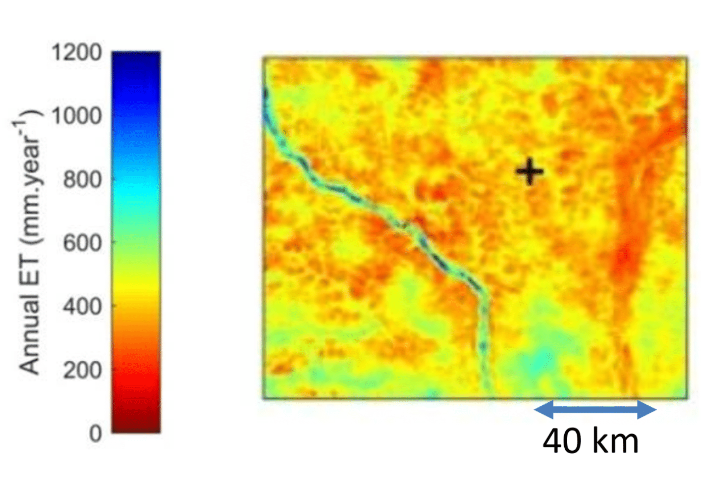
EVASPA – EVapotranspiration Assessment from SPAce
EVASPA provides daily time series of evapotranspiration, on irrigated or non-irrigated agricultural areas, at high resolution (less than 100 m).
Using thermal imagery (TIR), the cartographies rely on maps combining surface temperature, vegetation index and albedo within several surface energy balance models. They are compatible with large-scale applications (large irrigated perimeter, watersheds larger than 500 km², aquifer right-of-way, etc.) as well as with agronomic applications (crop water requirements, irrigation management, pumping estimates, etc.). ■
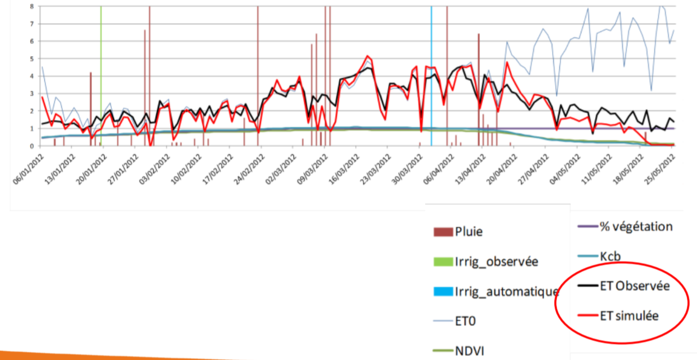
SAMIR – SAtellite Monitoring of IRrigation
SAMIR is a tool simulating the water balance of irrigated and non-irrigated agricultural areas at high resolution (Sentinel-2, Landsat). It estimates daily evapotranspiration using the FAO-56 method with forcing of vegetation characteristics from vegetation index (NDVI) time series and using daily meteorological data. Irrigation water inputs are simulated using assumptions about farmers’ practices (soil moisture threshold for triggering, doses, wet soil fraction, etc.).
This tool enables monitoring of the water balance on the scale of irrigated perimeters as well as estimates of pumping in aquifers. It is of particular interest to irrigation or watershed managers.
SAMIR has been developed within the framework of a collaboration between IRD (UMR CESBIO) and the University of Marrakech (www.lmi-trema.ma). The approach is currently being integrated into the MODSPA modelling platform developed at CESBIO. ■
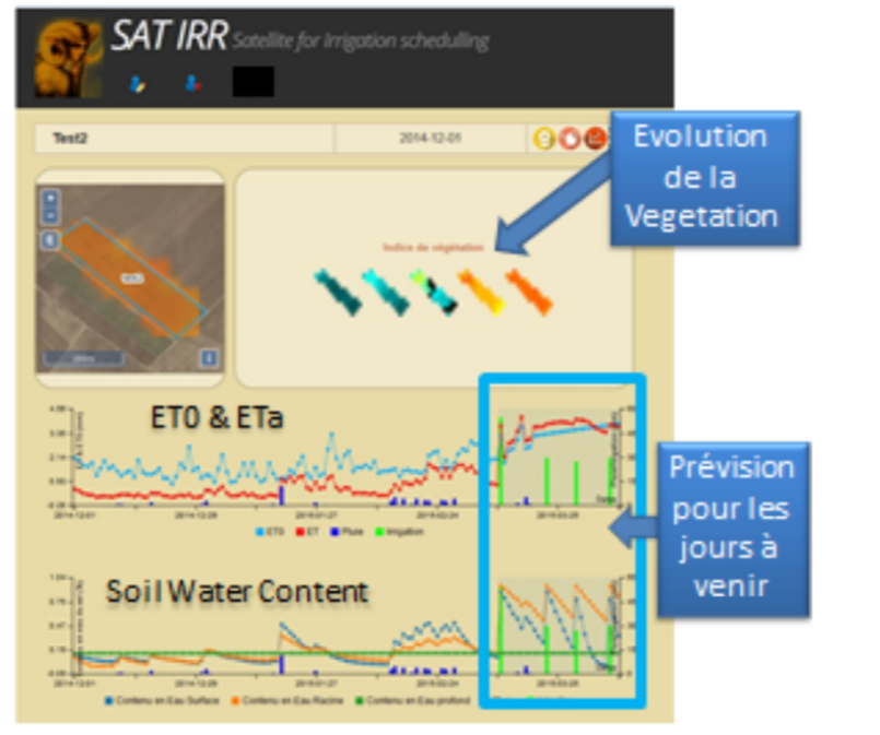
SAT-IRR – SATellite IRRigation Scheduling
SAT-IRR is an irrigation advisory tool for farmers.
At agricultural plot scale, it allows to translate evapotranspiration, simulated by a water balance model of the same type as SAMIR (FAO and NDVI), into soil moisture and irrigation date and irrigation depth to be applied.
SAT-IRR is available online ■
Schedule
- NDVI approach: SAMIR developed since 2004, calibration / validation studies are required for operational applications.
- SAT-IRR has been developed since 2014.
- TIR approach: operational since 2015
- Current objectives (2020):
- Continuation of calibration / validation activities (depending on the availability of reliable evapotranspiration measurements or irrigation volumes)
- Comparison of products from SAMIR with evapotranspiration estimates from the thermal approach (EVASPA, TSEB, etc.).
- Long-term objectives :
- Assimilation of thermal evapotranspiration products in SAMIR / SAT-IRR type models, a perspective offered by the future TIR HR , like TRISHNA .
- Assimilation of SAR information on soil moisture and water input to improve the water budget control.
Contact

Albert Olioso
INRAE | Emmah
ResearchGate

Vincent Simonneaux
Cesbio Toulouse
ResearchGate
@V.Simonneaux
For Sat-Irr

Michel Le Page
IRD | Cesbio | LMI TREMA
Google Scholar
@M.Le_Page