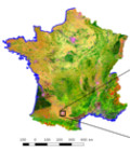
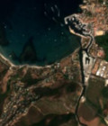
First land cover map of France for 2016 from Sentinel-2

The first land cover classification map of Metropolitan France for 2016 made from Sentinel-2 data at 10m resolution was released by the Land cover Scientific Expertise Centre on the 30th of March 2017.

For more information, see http://osr-cesbio.ups-tlse.fr

More information: Land cover mapLand cover CESSentinel-2

More news

Resumption of CNES THEIA CDS Production

The CDS THEIA Team at CNES is pleased to announce the resumption of value-added product production starting December 12, 2024, on its new production center. This production resumption, effective from […]

GEOV2-AVHRR: updated and consolidated plant data

The GEOV2-AVHRR collection includes the 2022 version of 3 essential vegetation variables (LAI, FAPAR, FCOVER). The whole data processing has also been updated.

Welcome to Sentinel-2C, but why not keep Sentinel-2A operational too?

The Sentinel-2C satellite was launched by ESA and the Copernicus programme on 4 September 2024 on a VEGA launcher. As soon as it is operational, nominally following an estimated 3-month […]

Search