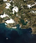
First Spot 5 (Take5) Ortho

The first Spot5 (Take5) image from the Lake Victoria image in Uganda has been ortho-rectified (L1C).

Registered with a similar product from Landsat 8, both images match very well, but we need to validate that much further.

We are starting to catch-up our late start due to the late definition of the sites. Most of the ancillary data for the 150 sites are ready (still missing the most Northern sites), and the first ortho-rectification was processed on the nominal configuration at Theia (CNES) by the Muscate exploitation team.

More information on : https://labo.obs-mip.fr/multitemp/?p=4981

More information: 

More news

Two THEIA LiDAR tools for forest monitoring

On this International Day of Forests, for which innovation has a major role to play in 2024, we are highlighting two tools dedicated to the management of aerial LiDAR data […]

SWOT data that exceeds expectations

The SWOT space mission was launched at the end of 2022 by CNES and NASA to document the water masses of the entire planet – oceans and continental waters. Data […]

Albédo Sentinel 2 THEIA pur l'Île-de-France, juin 2022

Measuring the albedo of mainland France from Sentinel-2

THEIA’s Albedo team has developed a method for calculating high-resolution (HR) albedo using Sentinel-2 data. The method has already been used as part of the Copernicus Global Land Service program, […]

Search