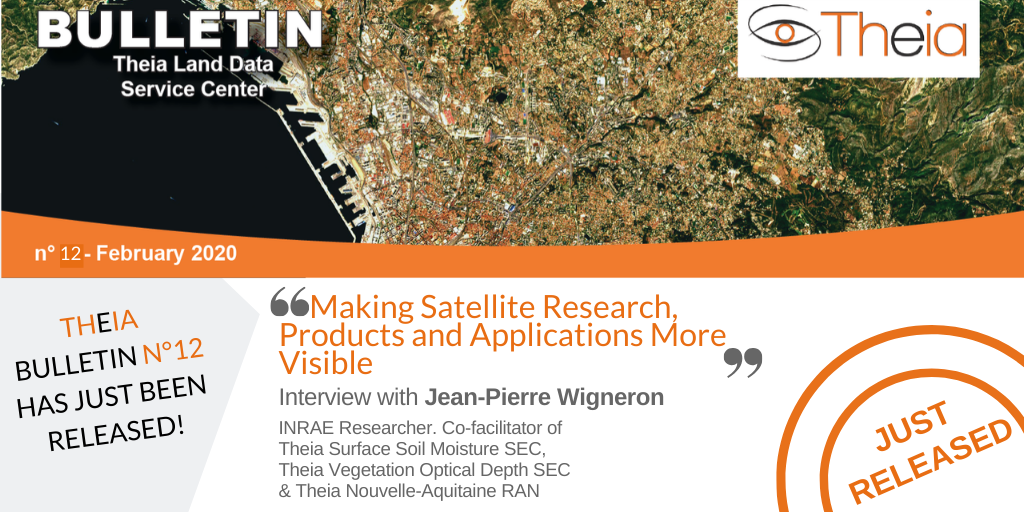
“Making Satellite Research, Products and Applications More Visible”

When and why did you get involved with Theia? What motivates you to get involved in a network like Theia?
Jean-Pierre Wigneron: I was involved in several committees whose work led to the creation of the Theia consortium, in particular the PTSC (Thematic Cluster on Continental Surfaces). At the Aquitaine level, I co-animated the AST Télédétection network (Transversal Scientific Action) of the OASU (Aquitaine Observatory of Sciences of the Universe) which aimed to create the first remote sensing network in the region. This network then provided a basis for the Theia Regional Animation Network (RAN) when it was set up. I also co-animated the remote-sensing network within INRA for many years.
Therefore, I naturally continued these different activities within the cluster when it was created. Theia plays an important role in making the work carried out in France on remote sensing visible to the supervisory authorities and ministries. Theia also provides real scientific animation and highlights the results obtained in the laboratories.
How is the link made between your work as a researcher and the actions within Theia?
Jean-Pierre Wigneron: My personal research and my scientific activities within Theia are very intertwined. I take part in Theia Surface Soil Moisture SEC and the brand new Theia Vegetation Optical Depth (VOD) SEC that I initiated and whose work is very close to my personal research. In both cases, the aim is to show the contribution of microwave data in the monitoring of the water and carbon cycle through soil moisture and biomass variables. The work launched in the VOD SEC, for example, is based on the results of various experimental campaigns that I was able to carry out at INRA in Avignon in the inversion of VOD on plots of soybean, wheat or corn almost 30 years ago. Thus, it is almost the same model (L-MEB for L-band Microwave Emission of the Biosphere) developed and calibrated on these agricultural fields that is now used in algorithms of the SMOS mission, showing the robustness of a valid approach from the plot scale to a continental or global scale (from a soybean plot to tropical forests with almost the same data processing algorithm!). These different results validate the potential of passive microwave data to measure canopy biomass and soil moisture, and thus to propose a development of these products in Theia. Why? Firstly, to offer an increased visibility to this work, to use the sounding board of Theia to make it known and to develop its use in applications. This is what we are doing with experts on the water and carbon cycle (P. Ciais, A. Ducharne, J. Chave etc. and many others internationally).
Moreover, one of the current challenges of remote-sensing is to succeed in combining Earth observation data in monitoring the functioning of the cover. For example, for forest monitoring, it is particularly interesting to combine information on soil moisture and surface temperature for monitoring water stress, biomass, LAI to monitor photosynthetic activity and phenology, etc. Most applications today rely on the combination of space-based observations. Theia, by promoting exchanges and collaborations within the community, is helping to make this possible.
What are the challenges today for the future of satellite in France and for Theia?
Jean-Pierre Wigneron: From what I observe in France today, there is quite strong support for the development of new sensors and new products. We now need to succeed in obtaining equivalent support for the development of applications based on these products in order to valorise them within major research institutes, such as INRAE or CNRS. Indeed, the purpose of remote sensing is not to produce a series of images or products, but to support applications on the water and carbon cycle, the functioning of ecosystems, etc. Tn many cases, remote sensing is an indispensable tool on scientific fronts that cannot be tackled effectively without the contribution of space observations. For me, Theia therefore has an important “political” role in raising awareness of this challenge among the supervisory authorities and research institutions, by highlighting and showing the value of the applications developed.

Jean-Pierre Wigneron
INRAE | SMOS-IC
ResearchGate
Contributions FR | EN