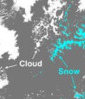
Operational production of the Snow collection

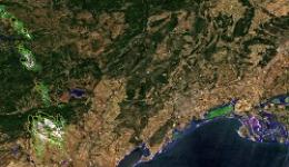
Maps of snow cover area at 20m resolution generated from Sentinel-2 observations are available every 5 days on theia.cnes.fr.

The Snow collection will progressively cover most mountain regions in west Europe, but also the Atlas in Morocco, eastern Canada…

The Snow collection can be freely downloaded from theia.cnes.fr by any registered user.


More information: SnowSnow-covered surface CESSnow / Ice

More news

Two THEIA LiDAR tools for forest monitoring

On this International Day of Forests, for which innovation has a major role to play in 2024, we are highlighting two tools dedicated to the management of aerial LiDAR data […]

SWOT data that exceeds expectations

The SWOT space mission was launched at the end of 2022 by CNES and NASA to document the water masses of the entire planet – oceans and continental waters. Data […]

Albédo Sentinel 2 THEIA pur l'Île-de-France, juin 2022

Measuring the albedo of mainland France from Sentinel-2

THEIA’s Albedo team has developed a method for calculating high-resolution (HR) albedo using Sentinel-2 data. The method has already been used as part of the Copernicus Global Land Service program, […]

Search