Data Access
| Product | Area | Time | Licence | Access |
|---|---|---|---|---|
| Land Cover | Buriram, Thailand | 2006-2008 | CC BY-NC 4.0 | aware.cirad.fr |
| Land Cover | Loei, Thailand | 2007-2008 | CC BY-NC 4.0 | aware.cirad.fr |
| Land Cover | Luang Prabang, Laos | 2006-2007 | CC BY-NC 4.0 | aware.cirad.fr |
| Land Cover | Mondolkiri, Cambodia | 2008 | CC BY-NC 4.0 | aware.cirad.fr |
| Land Cover | Nan, Thailand | 2006-2007 | CC BY-NC 4.0 | aware.cirad.fr |
| Land Cover | Champasak, Laos | 2007 | CC BY-NC 4.0 | aware.cirad.fr |
| Land Cover | Preah Sihanouk, Cambodia | 2006-2007 | CC BY-NC 4.0 | aware.cirad.fr |
| Land Cover | Chiang Rai, Thailand | 2010-2012 | CC BY-NC 4.0 | aware.cirad.fr |
| Land Cover | Kalasin, Thailand, | 2011-2013 | CC BY-NC 4.0 | aware.cirad.fr |
| Land Cover | Lapsik, Laos | 2010-2012 | CC BY-NC 4.0 | aware.cirad.fr |
| Land Cover | Prachuap Khiri Khan, Thailand | 2011-2013 | CC BY-NC 4.0 | aware.cirad.fr |
| Land Cover | Tha Wang Pha, Thailand | 2016 | CC BY-NC 4.0 | aware.cirad.fr |
| Land Cover | Tonle Sap Lake, Cambodia | 2012-2014 | CC BY-NC 4.0 | aware.cirad.fr |
| Land Cover | Kanchanaburi, Thailand | 2011-2013 | CC BY-NC 4.0 | aware.cirad.fr |
| Land Cover | Kandal, Cambodia | 2014-2015 | CC BY-NC 4.0 | aware.cirad.fr |
| Land Cover | Brasilia, Brasil | 2017 to 2019 | CC BY-NC 4.0 | GeoDEV |
| Land Cover | Guyane-Brasil Border | Since 2017 | CC BY-NC 4.0 | GeoDEV |
Description
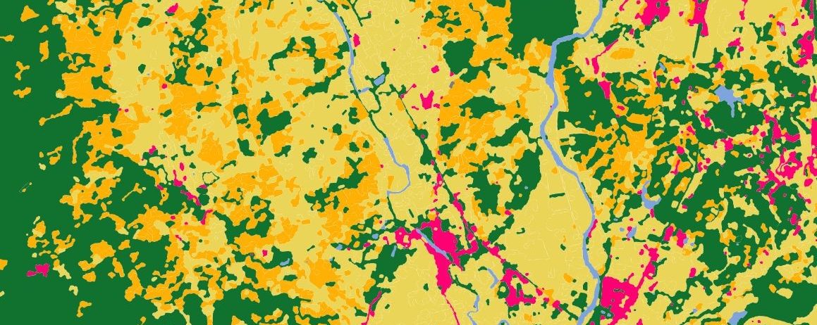
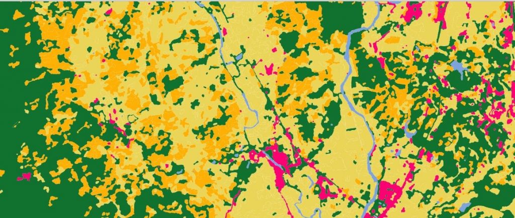
Theia Risks Associated with Infectious Diseases SEC proposes geographical layers of land cover, derived from SPOT imagery, for different study sites located in South East Asia (Cambodia, Laos, Thailand), between 2006 and 2016.
Land cover and landscape structure are indeed determinants of the distribution of rodents and their pathogens in Southeast Asia. The same typology was adopted for all the sites, which makes it possible to study the relationships between landscape, biodiversity and infectious risks.
Format
References
Morand S., Blasdell K.R., Bordes F., Buchy P., Carcy B., Chaisiri K., Chaval Y., Claude J., Cosson J.F., Desquesnes M., Jittapalapong S., Jiyipong T., Karnchanabanthoen A., Pornpan P., Rolain J.M., Tran A.. 2019. Changing landscapes of Southeast Asia and rodent-borne diseases: decreased diversity but increased transmission risks. Ecological Applications, 29 (4) : 15 p.. doi.org/10.1002/eap.1886
Data : https://doi.org/10.5061/dryad.s6s9p58
Blasdell K.R., Morand S., Henttonen H., Tran A., Buchy P.. 2016. Hantavirus seropositivity in rodents in relation to habitat heterogeneity in human-shaped landscapes of Southeast Asia. Spatial and Spatio-Temporal Epidemiology, 17 : p. 27-35. doi.org/10.1016/j.sste.2016.04.002
Della Rossa P., Tantrakarnapa K., Sutdan D., Kasetsinsombat K., Cosson J.F., Supputamongkol Y., Chaisiri K., Tran A., Supputamongkol S., Binot A., Lajaunie C., Morand S.. 2016. Environmental factors and public health policy associated with human and rodent infection by leptospirosis: a land cover-based study in Nan province, Thailand. Epidemiology and Infection, 144 (7) : p. 1550-1562. doi.org/10.1017/S0950268815002903
Blasdell K.R., Bordes F., Chaisiri K., Chaval Y., Claude J., Cosson J.F., Latinne A., Michaux J., Morand S., Pagès M., Tran A.. 2015. Progress on research on rodents and rodent-borne zoonoses in South-east Asia. Wildlife Research, 42 (2) : p. 98-107. doi.org/10.1071/WR14201
Pumhom P., Morand S., Tran A., Jittapalapong S., Desquesnes M.. 2015. Trypanosoma from rodents as potential source of infection in human-shaped landscapes of South-East Asia. Veterinary Parasitology, 208 (3-4) : p. 174-180. doi.org/10.1016/j.vetpar.2014.12.027
Bordes F., Morand S., Pilosof S., Claude J., Krasnov B.R., Cosson J.F., Chaval Y., Ribas A., Chaisiri K., Blasdell K.R., Herbreteau V., Dupuy S., Tran A.. 2015. Habitat fragmentation alters the properties of a host-parasite network: rodents and their helminths in South-East Asia. Journal of Animal Ecology, 84 (5) : p. 1253-1263.
doi.org/10.1111/1365-2656.12368
Données doi.org/10.5061/dryad.bf63c
Morand S., Bordes F., Blasdell K.R., Pilosof S., Cornu J.F., Chaisiri K., Chaval Y., Cosson J.F., Claude J., Feyfant T., Herbreteau V., Dupuy S., Tran A.. 2015. Assessing the distribution of disease-bearing rodents in human-modified tropical landscapes. Journal of Applied Ecology, 52 (3) : p. 784-794. doi.org/10.1111/1365-2664.12414
Bordes F., Herbreteau V., Dupuy S., Chaval Y., Tran A., Morand S.. 2013. The diversity of microparasites of rodents: A comparative analysis that helps in identifying rodent-borne rich habitats in Southeast Asia. Infection Ecology and Epidemiology, 1 (20178) : 10 p.. doi.org/10.3402/iee.v3i0.20178
Dupuy S., Herbreteau V., Feyfant T., Morand S., Tran A.. 2012. Land-cover dynamics in Southeast Asia: Contribution of object-oriented techniques for change detection. In : Pontifical Catholic University of Rio de Janeiro (PUC-Rio) ; Brazilian National Institute for Space Research (INPE). 4th International Conference on GEographic Object-Based Image Analysis (GEOBIA 2012), Rio de Janeiro, Brésil, 07- 09 may 2012. s.l. : s.n., p. 217-222. International Conference on GEographic Object-Based Image Analysis (GEOBIA 2012). 4, 2012-05-07/2012-05-09, Rio de Janeiro (Brésil).
http://mtc-m18.sid.inpe.br/col/sid.inpe.br/mtc-m18/2012/05.31.23.00/doc/goto-/sid.inpe.br/mtc-m18/2012/05.14.18.46