Data access
Presentation
In the framework of the GEOLAND project, IMP (University of Vienna) and EARS assess the precipitation amount from geo-stationnary sensors images using various approaches for applications of the Observatory Natural Carbon (ONC) and of the Observatory Food Security and Crop Monitoring (OFM).
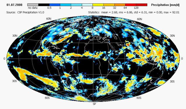
Combined daily satellite gauge precipitation product for July 2000
For IMP, the goal is to develop a global scale daily precipitation product based on existing multi-satellite products and bias-corrected precipitation gauge analyses. The objective is to improve the GPCP-1DD global product (Huffman et al, 2001), verified over Europe by Rubel et al. (2002), with a better calibration making use of daily bias-corrected rain gauge analyses based on about 6000 synoptic stations. IMP uses the GPCP-1DD multi-satellite product derived from geo-stationary sensors data in the 40° north-south belt, and TOVS data from the polar orbiting NOAA-12 and NOAA-14.
This product is calibrated with monthly precipitation data being near-real-time available based upon SYNOP and CLIMAT reports from GPCC (Global Precipitation Climatology Center). Currently, there does not exist any operational global daily precipitation product, which is based on bias-corrected gauge analyses. IMP has collected global daily rain gauge data for the period 1997-2003, and corrected them for systematic measurement errors. The bias correction of the ground-based precipitation measurements is needed, because of the under-catch of operational rain gauges, which is on the order of 5-30 percent on average. Then, the rain gauge data is interpolated to a global regular 1° longitude/latitude grid. GPCP-1DD satellite product and rain-gauge measurements are co-kriged to estimate the final precipitation product (see example above). Based on the first results of the FP5 demonstration project ELDAS, a combined gauge-satellite data set for the period 1997-present has been compiled and verified over selected regions of the globe, mainly located in Europe. This includes the collection of dense precipitation measurements (non-synoptic) for verification purposes as well as the calculation of verification scores to demonstrate the expected improvements.
Format
The Precipitation product, available daily for the period 1997 – 2005, can be downloaded with an algorithmic documentation (ATBD) and a technical documentation (readme).
EARS provides the rainfall product generated by the EWBMS system. The retrieval algorithm is based upon the discrimination of cloud top levels in hourly satellite imagery, using temperature thresholds. For each level the cloud duration is counted hourly during a period of 10 days. Rain gauge data are obtained daily from the WMO-GTS system. A local regression based on the observations on a given rainfall station and on the closest 11 surrounding stations is applied. The regression coefficients and the residual are subsequently interpolated between the rainfall stations for each pixel. Hereafter, the rainfall is determined on a pixel basis.
Contact
To get the products provided by EARS, it is necessary to make a request at the address ears@ears.nl.
References
Huffman, G.J., R.F. Adler, M.M. Morrissey, S. Curtis, R. Joyce, B. McGavock, and J. Susskind, Global precipitation at one-degree daily resolution from multi-satellite observations, J. Hydrometeor., 2, 36-50, 2001.
Rubel, F., P. Skomorowski, and B. Rudolf, Verification scores for the operational GPCP-1DD product over the European Alps, Meteorol. Z., 11, 367-370, 2002.