Data access
Presentation
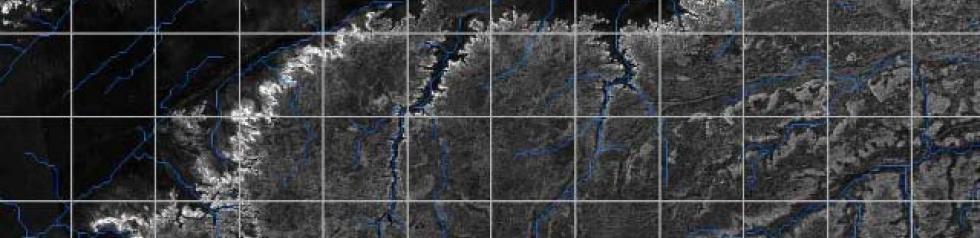
The SaharaSAR project was kicked off in 2008 in cooperation with Japanese aerospace agency JAXA and supported by CNES. A radar imagery mosaic using the PALSAR sensor (L-band, HH and HV polarisations, 50-metre resolution) was assembled by the Bordeaux Astrophysics Laboratory in order to study the geomorphology of North African desert regions. The PALSAR low-frequency orbital imaging radar can acquire imagery of ancient geological structures buried under a few metres of aeolian deposits. Indeed, the SaharaSAR mosaic revealed two former rivers in the Libyan Desert and the west of Mauritania. This unique dataset may be used for applications ranging from the study of the North African climate in ancient times to more modern preoccupations such as mapping fossil water resources.
Data from the SaharaSAR project are available via a dedicated website at http://saharasar.obs.u-bordeaux1.fr. This site allows you to display and download the geocoded PALSAR maps by 1×1-degree blocks. Using a radar image overlay, the maps indicate hydrographic HydroSHEDS information calculated on the basis of SRTM topography. Access to data is free of charge but requires the creation of an account indicating the user’s contact information and the purpose of the study. PALSAR data covering the whole of the Gobi desert in Central Asia are currently being integrated.
Contact

Philippe Paillou
Université de Bordeaux
Philippe Paillou
Satellite
Name : Palsar
Imaging mode : Radar
Spectral bands : L Band (1270 MHz)
Incidence : 34°
Polarization : HH
Resolution : 100 m
Observation capability : Unique observation, 1° x 1° square (SRTM stakable)
Coverage:
- Areas : Sahara, Arabia
- Period : 2007-2008
For more information see earth.esa.int.