Data access:
Presentation
In the framework of the GEOLAND project, Vienna University of Technology (IPF) and University of Bonn assess soil moisture parameters from active and passive micro-wave sensors measurements, respectively. These products are necessary to the Observatory Natural Carbon (ONC) as input of SVAT scheme for carbon and water cycle modelling, and to the Observatory Food Security and Crop Monitoring (OFM) to calculate the Crop Performance Index and the Crop Yield.
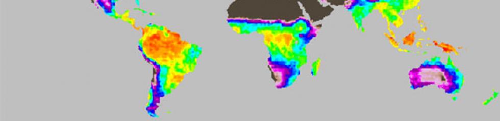
Global monthly mean Soil Water Index (1992-2000)
derived from the ERS / Scatterometer
IPF retrieves soil moisture using an advanced change detection approach (Wagner et al., 1999b) which fully exploits the sensor design of the ERS scatterometers with three antennas simultaneously observing the Earth surface at different look directions and the availability of 10 years of high quality backscatter data. A reference backscatter value representing backscatter from the vegetated land surface under dry soil conditions is subtracted from the actual incidence-angle normalized measurements to account for roughness and heterogeneous land cover. In Wagner et al. (1999a), the method has been refined to account for the effects of plant growth and decay by exploiting the multi-incidence capabilities of the ERS scatterometer. As a result, time series of the topsoil moisture content ms (< 5 cm) are obtained. It is a relative quantity ranging between 0 (dry) and 1 (saturated). In order to retrieve soil moisture in the root zone (up to about one meter) a two-layer water balance model, which only considers the exchange of soil water between the topmost remotely sensed layer and the “reservoir” below, was used to establish a relationship between the ms series and the profile soil moisture content (Ceballos et al., 2005). The resulting quantity is called the Soil Water Index (SWI) and ranges between 0 (wilting level) and 1 (field capacity). The dependency of the reflected signal with the incidence angle depends on the amount of vegetation on the surface. For correcting vegetation effects, we use the fact that there exists an incidence angle, which varies with the moisture conditions, where the effect of vegetation is minimized. Soil moisture is retrieved using a linear relationship with the vegetation corrected signal, the highest (representing saturated soils) and the lowest measurements (representing dry soils) ever recorded. For desert regions where saturated conditions are potentially never observed, this relationship is artificially forced. The ERS-Scatterometer soil moisture database is also available in the IPF website.
Format
The Soil Moisture products are available for the period 1992 – 2000 (animation above). They can be downloaded together with an algorithmic documentation (ATBD) and a technical documentation (readme).
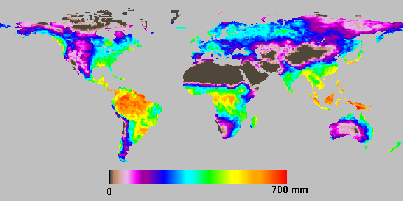
Soil moisture derived from AMSR, central decade of July 2003
The Soil Moisture products derived from AMSR data are available for the years 2003 and 2004. They can be downloaded together with an algorithmic documentation (ATBD) and a technical documentation (readme).
As the soil moisture datasets derived from ERS scatterometer and from Aqua/AMSR do not overlap, a direct comparison is not possible. A validation study is under progress at IPF to compare both soil moisture datasets to the in-situ measurements of the RHEMEDUS network in Central Spain where soil moisture parameters are collected since 1999.
References
Wagner, W., G. Lemoine, M. Borgeaud, and H. Rott, A study of vegetation cover effects on ERS scatterometer and soil data, Remote Sensing of Environment, 37(2), 938-948, 1999a.
Wagner, W., G. Lemoine, H. Rott, A method for estimating soil moisture from ERS scatterometer and soil data, Remote Sensing of Environment, Vol. 70, pp. 191-207, 1999b.
Drusch, M., E. F. Wood, and T. Jackson, Vegetative and atmospheric corrections for the soil moisture retrieval from passive microwave remote sensing data : results from the Southern Great Plains Hydrology Experiment 1997. Journal of Hydrometeorology, 2, 181-192, 2001.