Data Access
Presentation

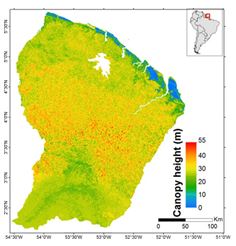
A canopy height for French Guiana obtained using the data fusion of LiDAR, optical and other environmental datasets. The precision of the map by comparison to a high precision airborne LiDAR canopy height estimates was evaluated at around 3 m (mean canopy height of 30 m).
Authors: Ibrahim Fayad (Irstea), Nicolas Baghdadi (Irstea), Jean Stéphane Bailly (AgroParisTech), Nicolas Barbier (IRD), Valéry Gond (CIRAD), Bruno Hérault (CIRAD), Mahmoud El Hajj (Noveltis), Frédéric Fabre (Astrium/EADS), José Perrin (BRGM).
Thanks: IRSTEA, CNES (TOSCA), BRGM, CIRAD, IRD, CNRS, Noveltis, Astrium/EADS, NSDIC (National Snow and Ice Data Center for the distribution of the ICESat/GLAS data),ONF.
References
Fayad I., Baghdadi N.,Bailly J.S., Barbier N., Gond V., El Hajj M., Fabre F., and Bourgine B., 2014. Canopy height estimation in French Guiana with LiDAR ICESat/GLAS data using principal component analysis and random forest regressions, Remote Sensing, vol. 6, pp.11883-11914, doi: 10.3390/rs61211883.
Canopy height in French Guiana : Fayad, I., Baghdadi, N., Bailly, J.-S., Barbier, N., Gond, V., El Hajj, M., Fabre, F., Bourgine, B. (2018). Canopy height in French Guiana. Irstea. https://doi.org/10.17180/canopy-height-fr-guiana-2014
Contact

Nicolas Baghdadi
INRAE | Tetis
ResearchGate
Contributions
Format
Metadata:
GeoTIFF raster
NoData: -9999
EPSG: 32622
Resolution: 250 m
Pixel type: double precision (64 bits)
Data years
ICESat: 2003-2009
BRGM: 1996
Altoa: 2004-2009
Données optique: 2003-2013
SRTM: 2000
Données Géologique: 2001