
Presentation
Theia “Risks Associated with Infectious Diseases” scientific expertise centre (SEC) brings together research teams from UMR Astre, UMR Tetis, UMR Espace-Dev, UMR IDEES, CRC-Université de Bourgogne and Cnes, all developing transmission risk maps for the various infectious diseases, vector-borne or otherwise, using Earth Observation data.
These products are destined to help spread information on epidemiological risks linked to infectious diseases among public health care players.
Risk maps, modelling and mapping tools and land use maps
The products proposed are risk maps, defined in terms of the probability of cases occurring or the presence of vectors :
- For various infectious diseases: Nil fever, Rift Valley fever, malaria, dengue or chickungunya
- For various areas of study (Europe, Africa, South America, Asia and the Indian Ocean)
- At different space scales
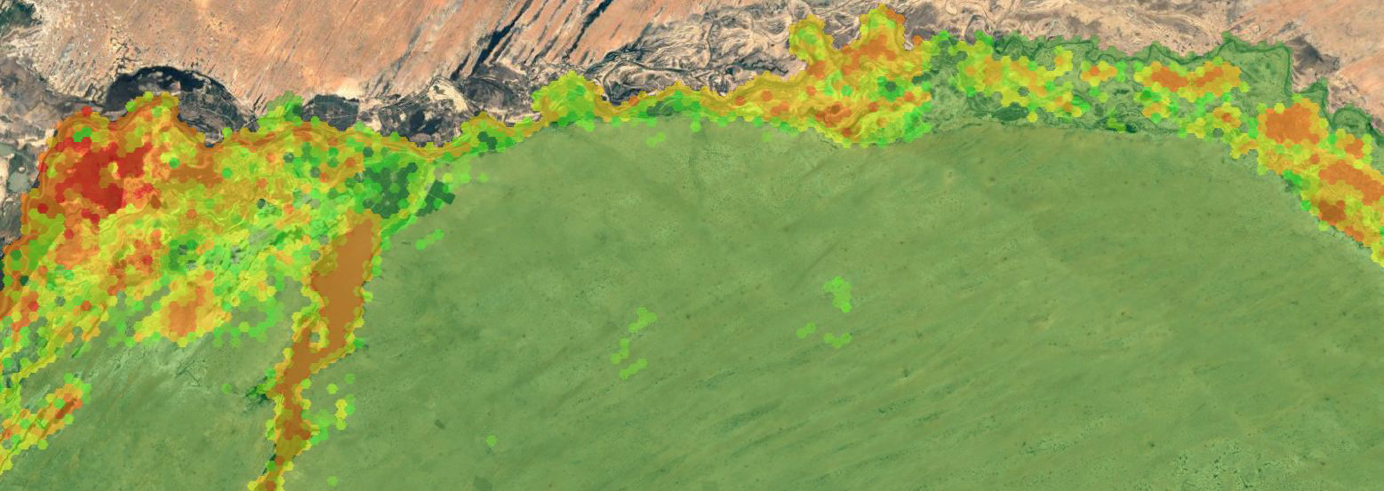
Risk maps
| Product | Area | Time | Licence | Access |
|---|---|---|---|---|
| Spatial modeling of mosquito vectors for Rift Valley fever virus in Northern Senegal | North Senegal | 2014-2016 | CC BY-NC 4.0 | DataVerse |
| Map of rat fleas vector for murins typhus distribution | Reunion Island | 2018 | CC BY-NC 4.0 | DataVerse |
Mapping and Modelling tools
| Product | Area | Licence | Access |
|---|---|---|---|
| ALBOMAURICE |a model of Aedes albopictus mosquito population dynamics, developed for Mauritius | Mauritius | CC BY-NC 4.0 | DataVerse |
| ALBORUN | a model of Aedes albopictus mosquito population dynamics, developed for Reunion Island | Reunion Island | CC BY-NC 4.0 | DataVerse |
| ARBOCARTO | Mapping tool to predict the population density of Aedes vectors | _ | CC BY-NC 4.0 | DataVerse |
| NLHI -Normalized Landscape Hazard index | Python Code, a tool for mapping the influence of the landscape on the probability of human/vector interaction | CC BY-NC 4.0 | Framagit | |
| Geocoding python code for disease cases (e.g. dengue in Brazil) based on OSM | CC BY-NC 4.0 | Forthcoming |
Land Cover Maps for the study of health/environment relationships
| Product | Area | Time | Licence | Access |
|---|---|---|---|---|
| Water Surfaces | Hwangue National Park, Zimbabwe | 2018 | CC BY-NC 4.0 | Hwangue Gonarezhou North Kruger |
| Zimbabwe National Parks Land Cover | Hwangue, Gonarezhou & North Kruger National Park, Zimbabwe | 2018 | CC BY-NC 4.0 | Hwange Gonarezhou North Kruger |
| Land Cover | Buriram, Thailand | 2006-2008 | CC BY-NC 4.0 | aware.cirad.fr |
| Land Cover | Loei, Thailand | 2007-2008 | CC BY-NC 4.0 | aware.cirad.fr |
| Land Cover | Luang Prabang, Laos | 2006-2007 | CC BY-NC 4.0 | aware.cirad.fr |
| Land Cover | Mondolkiri,Cambodge | 2008 | CC BY-NC 4.0 | aware.cirad.fr |
| Land Cover | Nan, Thailand | 2006-2007 | CC BY-NC 4.0 | aware.cirad.fr |
| Land Cover | Champasak, Laos | 2007 | CC BY-NC 4.0 | aware.cirad.fr |
| Land Cover | Preah Sihanouk, Cambodge | 2006-2007 | CC BY-NC 4.0 | aware.cirad.fr |
| Land Cover | Chiang Rai, Thailand | 2010-2012 | CC BY-NC 4.0 | aware.cirad.fr |
| Land Cover | Kalasin, Thailand, | 2011-2013 | CC BY-NC 4.0 | aware.cirad.fr |
| Land Cover | Lapsik, Laos | 2010-2012 | CC BY-NC 4.0 | aware.cirad.fr |
| Land Cover | Prachuap Khiri Khan, Thailand | 2011-2013 | CC BY-NC 4.0 | aware.cirad.fr |
| Land Cover | Tha Wang Pha, Thailand | 2016 | CC BY-NC 4.0 | aware.cirad.fr |
| Land Cover | Tonle Sap Lake, Cambodge | 2012-2014 | CC BY-NC 4.0 | aware.cirad.fr |
| Land Cover | Kanchanaburi, Thailand | 2011-2013 | CC BY-NC 4.0 | aware.cirad.fr |
| Land Cover | Kandal, Cambodge | 2014-2015 | CC BY-NC 4.0 | aware.cirad.fr |
| Land Cover | Brasilia, Brasil | 2017 to 2019 | CC BY-NC 4.0 | GeoDEV |
| Land Cover | Guyane-Brasil Border | Since 2017 | CC BY-NC 4.0 | GeoDEV |
Contact

Annelise Tran
Cirad | Tetis
@A.Tran
Contributions


Thibault Catry
IRD | Espace DEV
ResearchGate
Contributions FR