Data access
Presentation
Launched by Vega from the French Guiana Space Centre on the night of 1 to 2 August 2017, VENµS (Vegetation and Environment New micro (µ) Satellite) is a satellite jointly developed by CNES and ISA (Israel Space Agency), and built by IAI (Israel Aerospace Industries). It carries two very different instruments, corresponding to a primary scientific mission and a secondary technological mission.
The scientific mission is based on the multispectral camera supplied by CNES, which provides images in 12 spectral bands, from blue to near infrared. It consists of two phases:
- The first phase called VM1 ran from November 2017 to November 2020
- The second phase called VM5 started in March 2022 and is expected to continue until mid-2024.
The spectral characteristics of the 12 bands are provided here.
VM1
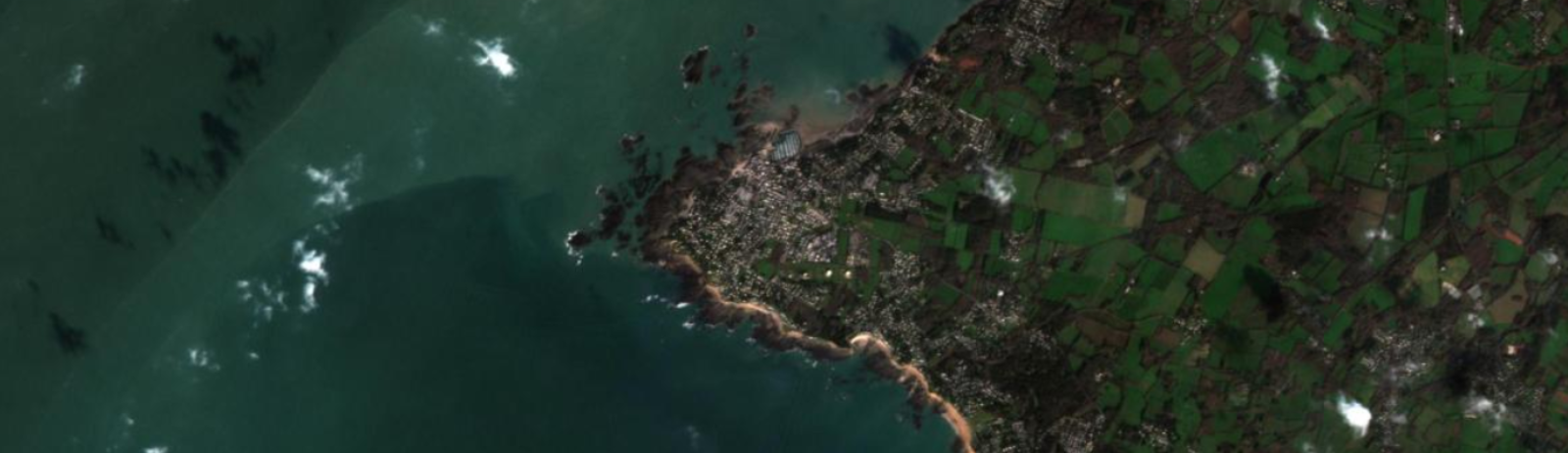
From November 2017, the VENµS satellite, orbiting at 720 km altitude, has been acquiring data on 123 different geographical areas with a resolution of 5 m every two days for scientists.
The areas selected, following a call for tenders to the scientific community, represent the main terrestrial, natural and cultivated ecosystems.
Geographical coverage
Some notions have to be explained in order to understand the number and the nature of the distributed data.
- The area : Venµs acquires 123 different areas during its 2-day orbital cycle
- The site : A site covers all or part of an area. In some cases (long areas, named as “composite”), a decomposition in elementary “sites” is made on the whole geographical footprint of the area. In the end, 159 different sites cover all the Venµs acquisitions.
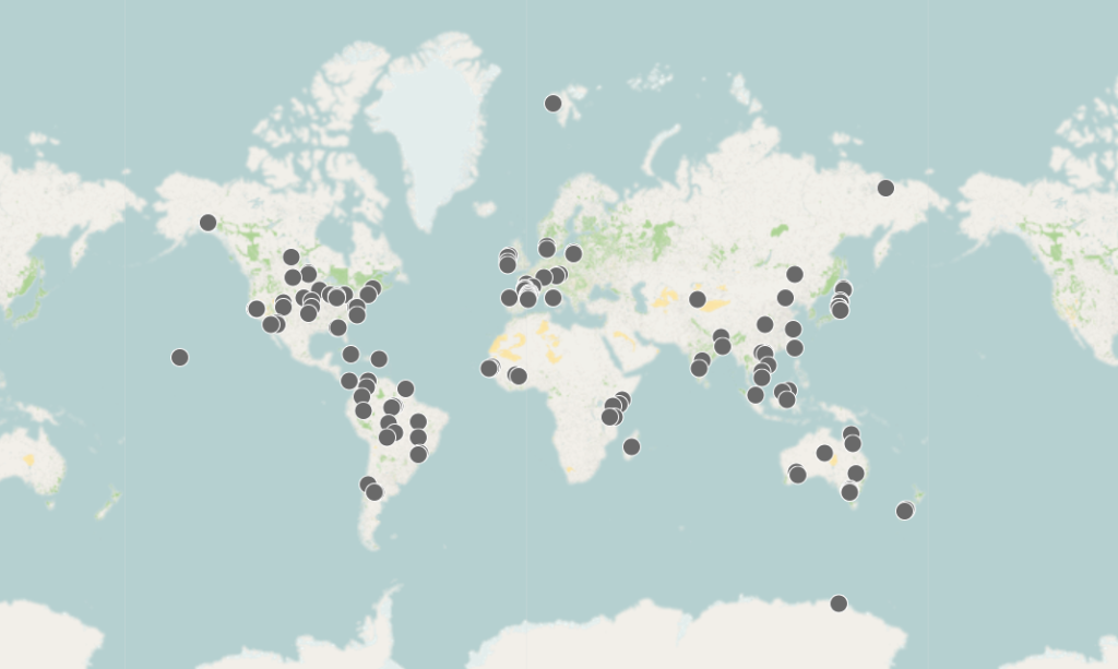
The data distributed are the image products related to the sites. Among the 159 sites, 27 cover Israel. The latter are not distributed through Theia portal. In the end, 132 sites are downloadable through Theia distribution portal.
The geographical distribution of these 132 sites is given here.
Venµs Top of the Atmosphere (TOA) Level 1 data is also available at
https://theia.cnes.fr/collection VM1
VM5
From March 2022 onwards, the VENµS satellite, in a new orbit at an altitude of 560 km, will perform acquisitions with revisits every one or two days depending on the site. The spectral characteristics remain identical to those of the VM1 phase, but the resolution of the images is increased to 4.1 m.
The call for scientific projects made it possible to select the areas compatible with this new phase of the scientific mission.
Geographical coverage
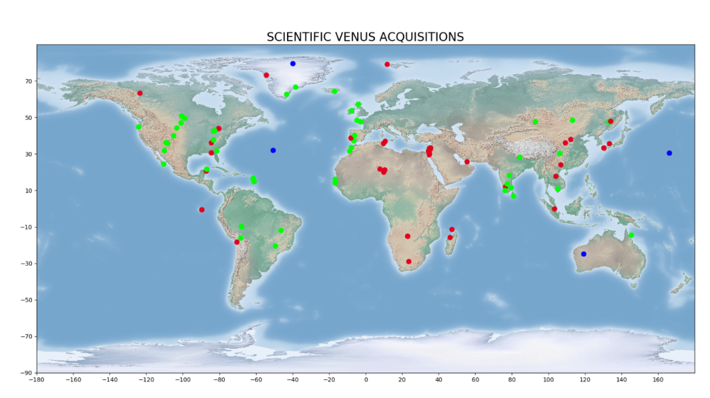
For VM5, 105 science sites (the exact list is still being developed to take into account the new characteristics of this one-day revisit orbit), selected following an international call for proposals, will be regularly acquired, covering a wide range of different climates and landscapes, as shown in this map.
With the exception of the Israeli sites, these sites will be freely available on the THEIA data portal. The geographical distribution is provided here.
VENµS Top of the Atmosphere (TOA) Level 1 data is also available at https://theia.cnes.fr/collection VM5
Contact

Olivier Hagolle
CNES|CESBIO
ResearchGate
@O.Hagolle
Contributions
Satellite
Name : Venµs
Imaging mode : optical
Spectral bands : 12 bands from visible to near infrared
Resolutions : 5 m
Observation capability :
- Swath : 27 km
- Revisit : 2 days
Coverage :
- Areas : 123 areas in the world, representing 159 elementary scientific sites
- Period : since 2017, December
For more information see venus.cnes.fr
Level
Level 1 : Single date product, Top Of Amosphere (TOA) reflectances, calibrated and geocoded.
Level 2 : Single date product, surface reflectances after cloud masking and atmospheric correction.
Level 3 : Multidate product, synthesis of cloud free pixels from the level 2 products acquired during a small period of time, it will be produced every 15 days.
Product format
Level 1
A simplistic description of the Venµs data is given here.
More information on geometric quality is available in pdf format or on the following website.
Further information on solar irradiance and the Earth-Sun distance of L1 metadata is available here.
The spectral characteristics of the Venµs camera are detailed here.
Level 2
Level 2A products provide atmospheric corrected surface reflectances and are supplied with a cloud mask and shadows.
Data processing is performed with the MAJA chain (formerly called MACCS) on behalf of the Theia data center.
MAJA Algorithm Theoretical Basis Document (ATBD)
License
The VENµS data distributed by THEIA are distributed under the terms of the Creative Commons Attribution-NonCommercial 4.0 International License.
For any communication based on these data, please comply with the terms of the licence as follows:
“Value-added data processed by CNES for the Theia data centre www.theia-land.fr/ from data from the CNES VENµS satellite and the Israeli space agency. The processing uses algorithms developed by Theia’s Scientific Expertise Centres.”