Sat’Irr: The Result of a Fruitful Partnership Between a Research Institute and a Company
The Institute of Research for Development (IRD), the Cadi Ayyad University of Marrakesh (UCA) and the company TerraNIS signed a technology transfer contract in March 2019 concerning the Sat’Irr (Satellite for Irrigation Scheduling) application.
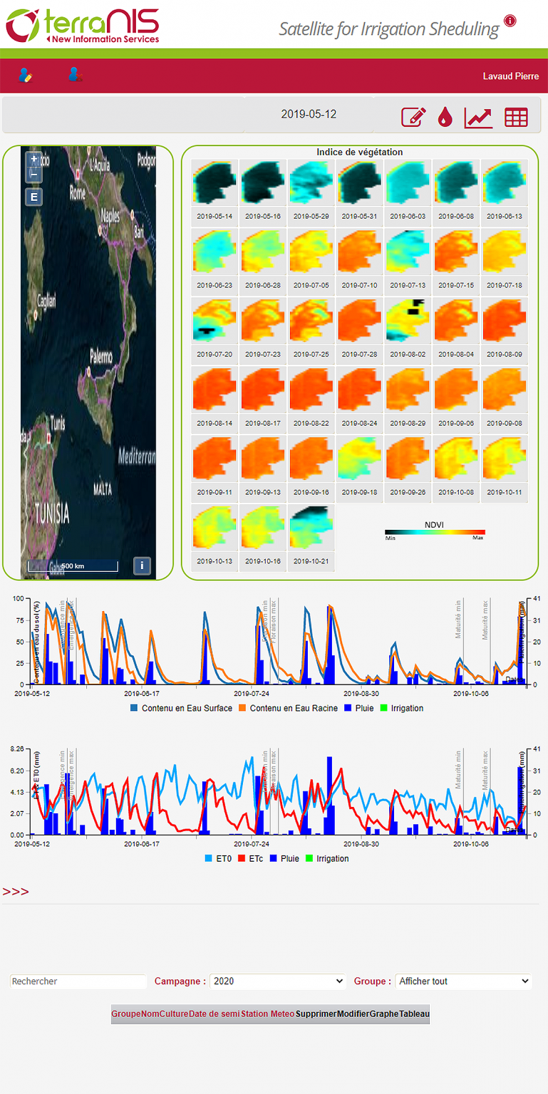
This tool is developed in the framework of a French-Moroccan collaboration within LMI TREMA – Laboratoire Mixte International de Télédétection et Ressources en Eau en Méditerranée semi-Aride (Joint International Laboratory for Remote Sensing and Water Resources in the Semi-Arid Mediterranean). It uses Earth observation images, meteorological data (observation and forecasting) and in-situ data (e.g. the soil characteristics of the agricultural parcel) to estimate the amount of water available to the plant in the soil. In case of drought, the application indicates to the farmer when and how much water to bring. This tool has been tested on several experimental sites in the South-West of France and in the Marrakesh region, Morocco.
Building a partnership
TerraNIS is a company based in Toulouse (France) and specialized in the design, development and marketing of geoinformation services using satellite imagery in the fields of agriculture, environment and land use planning. The development of innovative decision support tools for the optimization of natural resources and agroecology is a major development axis of the company. To implement this strategy, TerraNIS favours the creation of partnerships and the management of R&D projects.
It is within this dynamic that TerraNIS wanted to benefit from the transfer of Sat’Irr. The company’s objective was to optimize R&D investments by accessing to a technology that had already been developed and validated, while benefiting from strong scientific expertise in this field. Concerning the laboratory, the objective was to enhance the value of the research results and know-how acquired through operational use of the tool developed. The actual transfer took place in three stages:
- Theoretical and practical training on the operation of Sat’Irr. The aim was to enable TerraNIS teams, made up of agronomists, remote sensing specialists and computer scientists, to improve their skills on the subject and on the tools used.
- A deployment of the solution in the TerraNIS work environment in order to install a first instance on a server hosted within the company.
- The definition of a roadmap shared between Cesbio and TerraNIS in order to define the evolutions envisaged and the actions to be implemented. This last step seemed essential in order to guarantee the success of this transfer in the medium and long term.
Development and industrialisation
Following this first stage, new projects have been set up both within Cesbio and TerraNIS. Although the objectives differ, with scientific issues on the one hand and commercial issues on the other, close collaboration between the actors seems essential to guarantee the sustainability of the cooperation. Thus, the laboratory focuses mainly on the improvements to be made, in particular through better detection of water stress by thermal imaging and detection of irrigation by radar imaging. For its part, TerraNIS focuses on the industrialization of tools and the development of new functionalities in order to meet the specific needs of users. In parallel with these technical activities, TerraNIS is building the commercial offer by developing the marketing aspect. TerraNIS aims to market the tool from 2021 after a season of pre-operational tests in 2020.
The success of this technology transfer was made possible thanks to the proximity between the Cesbio laboratory and the company TerraNIS. This collaboration is a real opportunity to acquire, share and develop complementary tools, know-how and skills from Research and Industry.
Guillaume RIEU (TerraNIS)
www.terranis.fr