
SMOS L4RZSM, an operational product dedicated to root zone humidity
Determining the water stock in the root zone
humidity.
Measuring the moisture content of the first metre of soil is of major use for many ecosystem services and downstream applications. This layer of soil is the main water reservoir for crops. A lack of water in the root zone triggers water stress in vegetation and reduces yield. The root zone in wetlands is also a place overflowing with life with sustained biological activity. From a hydrological point of view, it is at the interface of the processes of run-off, vegetation transpiration and groundwater recharge. It is therefore a component of the critical zone par excellence.
An operational product
CESBIO has implemented an algorithm that allows the root zone humidity to be deduced from the surface humidity (0-5 cm) estimated from data from the SMOS satellite (CNES, ESA). SMOS is the first Earth observation satellite dedicated to measuring soil moisture using its 2D L-band interferometric radiometer
(1.4 GHz). Since January 2010, SMOS has made it possible to observe surface soil moisture (0-5 cm) twice (in descending and ascending orbit) every three days (at the equator) on a global scale.
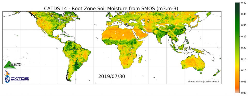
The algorithm for estimating root zone moisture has the characteristic of taking only the surface soil moisture as input. Also, the algorithm takes into account the soil texture in the transfer function from the surface to the different soil layers. The resulting product contains the root zone humidity in m3/m3 with a quality indicator taking into account the presence of radio interference, the presence of dense forest and the period between product updates. This period is impacted by various phenomena, for example, ground frost. A processor based on the algorithm in question has been prepared by CESBIO engineers for operational implementation at the SMOS Data Processing Centre (CATDS). It was configured by the engineers of the Production Centre (C-PDC) of the Back-End SMOS Data Processing Centre (CATDS) at Ifremer. Today, the L4RZSM daily product (Figure 1) is available to users via the CATDS website:
Users also have access to a base of ten years’ root zone humidity via the research product while awaiting homogeneous reprocessing of the entire SMOS series in 2021.
The product is supplied on the EASE2 grid at 25 km, consistent with the product’s input surface moisture sampling. The high revisit of SMOS allows the moisture in the root zone layers to be updated frequently.
This product incorporates Theia Surface Soil Moisture SEC giving access to root zone moisture. It is distributed with a license (Creative Common) like all CATDS products. In the next step, application to higher resolution surface moisture data from the multi-sensor fusion would provide a root zone moisture product at sub-kilometre resolution.
Applications around the root zone
The applications are multiple. First of all, we will mention the monitoring of agricultural drought. As agriculture alone uses 70% of the water extracted from the environment according to the FAO, monitoring agricultural drought is essential. Moreover, as drought generally occurs on a regional scale, this product is
particularly suitable.
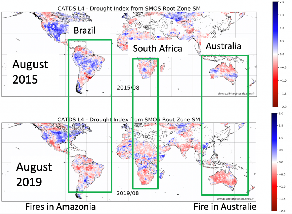
A database of moisture anomalies in the root zone is already available to users. The analysis of these anomalies makes it possible to show the intensity of the droughts in 2019 in Brazil and Australia, which led to huge forest fires (Figure 2).
Other applications concern the evaluation of the denitrification capacity of wet soils (ECOLAB/CESBIO/WMO). Indeed, soil plays a major role in the biogeochemical transformation of water and a global assessment of these processes is necessary.
CESBIO is currently working in collaboration with international institutes (IPH, Brazil; IISc Bangalore, India) on the contribution of these data to the calibration of large-scale hydrological models and operational drought monitoring.
Contact

Ahmad Al-Bitar
Cesbio
@A.Albitar
Contributors : Ali MAHMOODI (CESBIO), Yann KERR (CNES), and Stéphane TAROT (Ifremer)
To go further

Read the New Theia Bulletin
>>> Read on-line on Calaméo