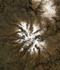
Spot 5 (Take5) first image

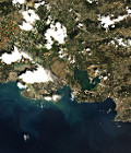
The first set of Spot5 (Take5) images was acquired on the 8th of April 2015 in Uganda.

Lake Victoria and Sigulu Island are part of the first set of images processed by Airbus Defence and Space at Level 1A. It is the proof that everything went well at all stages, from programming to acquisition and processing, despite the fact that Spot5 is not on its nominal orbit anymore.

This image will be followed by 29 more images on this site, acquired with a periodicity of five days. And the same will happen on 149 other sites.

More information on : https://labo.obs-mip.fr/multitemp/?p=4938

More information: 

More news

ForM@Ter and THEIA release a serie of very high resolution topographic models of 140 glaciers worldwide through the PGO FAIR collection

The Pléiades Glacier Observatorywas initiated in 2016 by French Space Agency (CNES), by the Laboratoire d’Etudes Géophysiques et Océanographiques Spatiales (LEGOS) and by the Institut National des Sciences de l’Univers […]

A World Glacier Atlas to understand glacier mechanisms in a global warming context

The 3 glacier products available on Theia offer an unprecedented global overview of the evolution of glaciers.

Land cover Theia product update

Like every year at this time, you’re invited to discover the new version of the OSO product, from the S.E.C Land cover. The 2022 version was released a few days […]

Search