Challenges
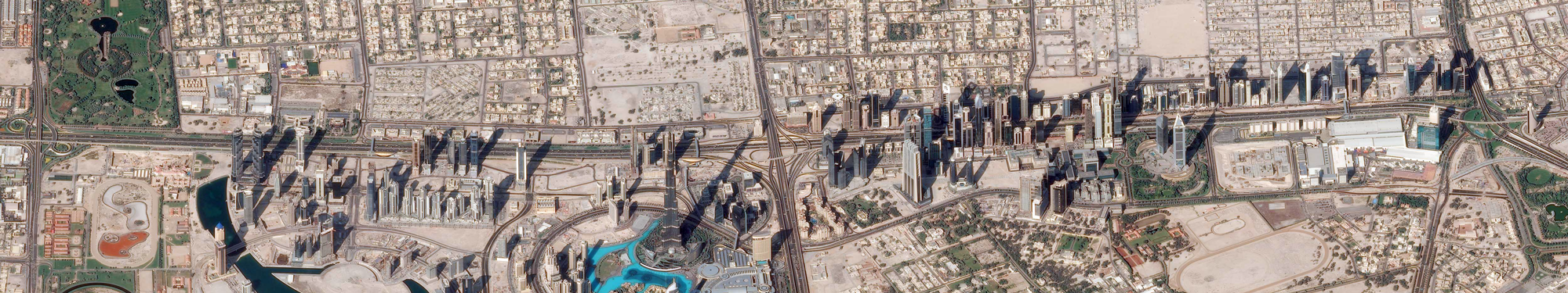
At a time of climate change and when the world population explosion is accompanied by rapid urbanization which itself causes a geometric expansion of urban areas, the challenges facing cities are colossal, and often highly differentiated according to the country’s level of development. Since 2008, for the first time in human history, more than half of the population has been living in urban areas. By 2050, it is estimated that about 70% of the world’s population will be urban. This number of inhabitants is not the only factor that can characterize urban development because urban forms and densities are very different around the world. This urbanization will weight heavily on natural resources on a large scale with tensions on available land, environments and biodiversity.
Food demand is expected to double, energy consumption to increase by 80% and water supply to grow by 55%. The sealing and increased artificialization of soils is already disrupting the flow of surface water and causing pollution problems that contribute to global climate change of the planet. Despite improvements in urban and rural planning, for example in France, the consumption of these areas remains too rapid, even in areas where the population and jobs are not increasing.
With these challenges, the detection, characterization and monitoring of the objects that make up this environment at different spatial scales, as well as urban phenomena or processes (waterproofing, artificialization, vegetalization, heat islands, etc.) have become essential in the context of monitoring and evaluating public policies for land use planning and biodiversity preservation and optimization.
Recently, there has been a growing proliferation of heterogeneous geo-spatial data (aerial or terrestrial photographs with very high or even extremely high spatial resolution, satellite images, particularly stereoscopic images, with high and very high spatial resolution), acquired with a very high temporal frequency by different platforms and sensors (e.g. with the new Sentinel satellite constellation). In addition, many satellite imagery archives (Landsat, SPOT SWH) are also available and are also an invaluable source of data for retrospective analyses.
Research issues
The city is a complex system and its impact on the environment is measured through several themes such as imperviousness, waterproofing, biodiversity, air and water quality, noise pollution or heat islands, etc. Remote sensing, through the diversity of available images, allows for diagnostics (inventory), impact studies, temporal monitoring or territorial prospective. The research questions are both scientific and methodological, including:
- Monitoring urban sprawl makes it possible to measure the progression of artificialized areas and to calculate several indicators such as the imperviousness of surfaces or the consumption of agricultural land. The availability of these spatio-temporal indicators can improve the implementation of urban development strategies;
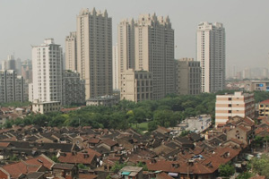
- Mapping and monitoring urban morphology: the impact of urbanized surfaces and energy exchanges between the urban surface and the urban canopy requires a precise knowledge of the types of surfaces and materials used for constructions. Multispectral or even hyperspectral images with high and very high spatial resolution can provide the information necessary for meteorological models and allow advances in the knowledge of the impacts of the city on its environment;
- Mapping and monitoring urban vegetation: the issue of urban vegetation has grown considerably in recent years in relation to several themes such as urban biodiversity, the well-being of urban populations, the quality of the living environment and the impact of vegetated areas on the intensity of the urban heat island and, more generally, on urban heat island.
- Mapping elements at risks exposed to natural and/or anthropogenic hazard. The identification of structural issues, natural or other amenities within the risk perimeter can enable the implementation of adaptation strategies for these areas.
Theia products on Urban area


Applications
Current projects
- ‘Image, Ville Environnement’ lab (LIVE) pilots the ANR TIMES project “High performance processing techniques for mapping and monitoring environmental changes with massive, heterogeneous and high frequency data TIMES series” (2017-2021), whose objectives are to generate new knowledge on environmental dynamics from the exploitation of massive and heterogeneous geospatial data. The aim is to propose and develop new methods for exploiting complementarity and, above all, high temporal frequency, particularly Sentinel images, in order to respond to societal and environmental issues, particularly in urban areas.
- The TOSCA project ‘Artificialization – Urbanization’ (2016-2018) aimed to federate laboratories working on urban issues in order to support the activities of the Urban CES. Thus, this project allowed (i) to develop the use of remote sensing tools, methods and data applied to this issue, and (ii) to enhance and qualify the information and promote its appropriation by the users. From an application point of view, the stakes are to ensure knowledge of the consumption of artificial surfaces for land management, in particular by producing national and updated maps of artificialized spaces, maps of urban fabrics, but also of ‘green’ surfaces in urban areas.
- The Action 7 Project of the National Biodiversity Plan (UMR Tetis, IGN), led by the French Ministry of Ecological Transition and Solidarity, brings together three public bodies (IGN, Cerema and Irstea). The objective, as defined in action 7, is to “[publish], every year, an inventory of land consumption and [make] transparent and comparable data available to territories and citizens at all territorial scales”.
- The Artisols Project (UMR Tetis), an ERDF project that brings together various public (Region, DRAAF, Irstea, Inra, Ensat) and private (BRL) partners in Occitanie. It aims to produce methods and spatialized indicators to monitor artificialisation in the new region and measure its impact in terms of consumption of land with agronomic potential.
- The URCLIM Project (ERA4CS, JPI Climate 2017-2020) – URban CLIMate services is a multidisciplinary research project dedicated to the realization of integrated Urban Climate Services (UCS) dedicated in particular to urban planning. This project aims in particular to develop a methodology for the creation of high spatial resolution maps of urban parameters useful for climate studies. These maps will be created both from existing geographic databases and from information extracted by remote sensing. URCLIM also aims to analyse the propagation of uncertainty in climate models from the regional to the city scale, but also in an even more localised manner for impact studies.
Doctoral Theses
- Analyse de séries temporelles massives d’images satellitaires pour le suivi de la dynamique des modes d’occupation des sols
Romain Wenger
Thèse en cours – LIVE CNRS UMR 7362 – Université de Strasbourg - Apport des données de télédétection à très haute résolution spatiale pour la cartographie de la végétation en milieu urbain : application à Rennes Métropole
Jean Nabucet
2018 – Thèse LETG-Rennes - Télédétection par analyse de retours d’onde LIDAR et spectrométrie à haute résolution des zones sensibles en environnement côtier et urbain
Antoin Ba
2017 – Thèse LETG-Rennes - Apport des images satellites à très haute résolution spatiale couplées à des données géographiques multi-sources pour l’analyse des espaces urbains
Simon Rougier
2016 – Thèse LIVE CNRS UMR 7362 – Université de Strasbourg