TRISHNA: a Franco-Indian Mission to Monitor the Water Status of Continental Ecosystems
A mission with a high temporal resolution
TRISHNA (Thermal infraRed Imaging Satellite for High-resolution Natural resource Assessment) is a future high-resolution space-time mission in the thermal infrared (TIR) led jointly by the French (CNES) and the Indian (ISRO) space agencies for a launch planned in 2025. The scientific objectives guiding the definition of the mission are, in order of priority, the monitoring of the water status and of the stress of continental ecosystems, the monitoring of coastal and inland waters, the urban environment, and applications to the solid Earth, the cryosphere and the atmosphere.
TRISHNA will be positioned on a polar orbit at an altitude of 761 km, providing a revisit of 3 passages over 8 days with global coverage. The time of passage around 13:00 LST allows thermal data to be acquired in the middle of the day, but also in the middle of the night. The instrument will offer 4 thermal channels (8.6 µm, 9.1 µm, 10.4 µm, 11.6 µm) and 6 optical channels (485 nm, 555 nm, 650 nm, 860 nm, 1 380 nm, 1 650 nm) with a spatial resolution between 50 m and 60 m for all channels. The required accuracy is 1k with a NeDT of 0.2K.
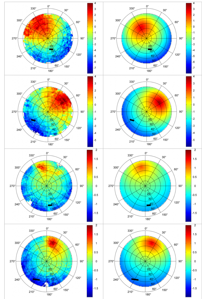
TRISHNA will have a large field of view of 35° to ensure global coverage, generating directional effects whose magnitude has been measured in situ up to 5°C (forests) and 10°C (vineyards, urban). In the intertropical zone and from March to October, one of the three successive observations will be contaminated by the hot spot phenomenon which consists in observing the target in the direction of illumination. Parametric models (Roujean-Lagouarde, RL), 1D (SCOPE) and 3D (DART) are being studied to best overcome angular stress based on better control of directional anisotropy in the IRT. The GWS (Global Split Window) and TES (Temperature Emissivity Separation) methods will be used to estimate the surface temperature corrected for atmospheric and emissivity effects.

A structured research system
A scientific mission group was structured into eight Franco-Indian thematic subgroups (Ecosystem stress, Coastal and Continental Waters, Urban, Cryosphere, Atmosphere, Solid Earth, Cal/Val, Product Development). The subgroups’ activities are multiple and range from the consolidation of mission specifications (directional variability, characterization of the impact of atmospheric turbulence, emissivity estimation, position and width of thermal spectra) to the definition of products and their validation on in situ networks. Finally, the subgroups ensure the link with Indian partners on each of the themes, in particular through scientific exchanges and the setting up of collaborative projects.
The ultimate objective is to co-construct future processing chains, to size and validate error items, and to promote the use and dissemination of data in the community. For example, an end-to-end simulator is being developed for vegetation in CNES for this purpose with the help of the “ecosystem braid” group.

Jean-Louis Roujean
CNRM
@J-L.Roujean
Read the New Theia Bulletin
>>> Read on-line on Calaméo


