Data access
Presentation
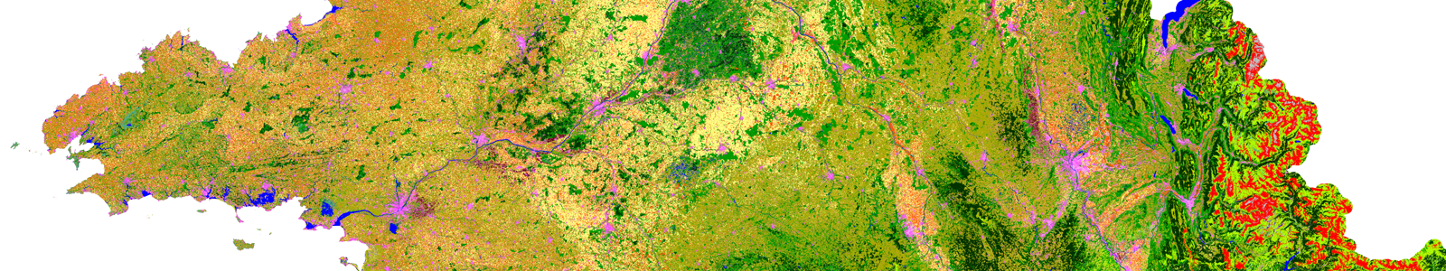
Theia Land Cover SEC produced automatically land cover maps for Metropolitan France using Sentinel-2A and Sentinel-2B data. These maps have a 10-meters resolution.
2020, 2019 and 2018 available maps use a 23-categories nomenclature:
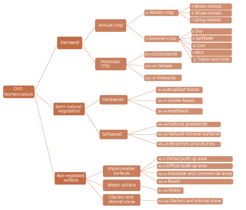
The nomenclature used since 2018 is furthermore totally compatible with the 17-classes nomenclature employed for the 2016 and 2017 land-cover maps.
Illustrating earlier work, 2009, 2010, 2011 and 2014 maps using Landsat-5 databases are also available.
Contact

Vincent Thierion
INRAE | CESBIO
@V.Thierion
Contributions FR

Silvia Valero
CESBIO
Google Scholar
@S.Valero
Format
Raster format
The classification raster is a single raster covering the whole French metropolitan territory. It has a spatial resolution of 10 m. It results from the processing of the complete Sentinel-2 time series of the reference year using the iota² processing chain. A Random Forest classification model is calibrated using a training dataset derived from a combination of several national and international vector data sources (BD TOPO IGN, Corine Land Cover, Urban Atlas, Référentiel Parcellaire Graphique, etc.).
Vector format
This is a product with a minimum collection unit of 0.1 ha derived from the 20 m raster with a procedure of regularization and a simplification of the polygons obtained.
In order to preserve as much information as possible from the raster product, each polygon is characterized by a set of attributes:
- The majority class, with the same nomenclature of the raster product.
- The average number of cloud-free images used for classification and the standard deviation. These attributes are named validmean and validstd.
- The confidence of the majority class obtained from the Random Forest classifier (value between 0 and 100).
- The percentage of the area covered by each class of the classification. This percentage is calculated on the 10m raster, even if the simplified polygons are derived from the 20m raster.
- The area of the polygon.
The product is clipped according to the administrative boundaries of the departments and stored in a zip archive containing the 4 files that make up the “ESRI Shapefile” format.
QGIS style files
Download a set of files to use OSO colour codes in QGIS.
Licence
Sentinel-2 level 2A or 3A data distributed by THEIA are distributed under the ETALAB V2.0 open licence, details of which are available here: Français | English.
For any communication based on these data, please comply with the mentions appearing in the license and listed below:
“Value-added data processed by CNES for the Theia data cluster www.theia.land.fr from Copernicus data. The processing uses algorithms developed by Theia’s Scientific Expertise Centres.”
DOI
OSO 2018 : 10.5281/zenodo.3613415
OSO 2019 : 10.5281/zenodo.6538321
OSO 2020 : 10.5281/zenodo.6538861
OSO 2021 : 10.5281/zenodo.6538910