Equipex Geosud project was selected as part of the call for proposals “Equipment of Excellence” in the Programme d’Investissements d’Avenir (large national bond issued in 2011). The project gathers 14 institutional partners. Research, higher education and the public management of the environment and territories are represented by: AgroParisTech, CETE Sud-Ouest, CINES, Cirad, CNRS, IGN, IRD, Irstea (coordinator), Université de Montpellier 2, Université Antilles Guyane and Université de la Réunion. Private partners or associations are also members: AFIGEO, Geomatys, and OZAPP.
A national satellite imagery infrastructure
Equipex Geosud’s mission is to develop a national satellite imagery infrastructure to serve the research on environment and territories and its applications in the management of public policies. It is also open to private partners in partnership with public players or in the frame of outsourcing. The objective is to contribute to the full development of the potential of satellite imagery. Thanks to its repetitive coverage at different resolutions and in different spectral bands, it is a valuable tool for the multi-scale analysis of the structures, the functioning and the dynamics of the ecosystems and territories. This satellite data infrastructure will also help these communities to network and share their experience.
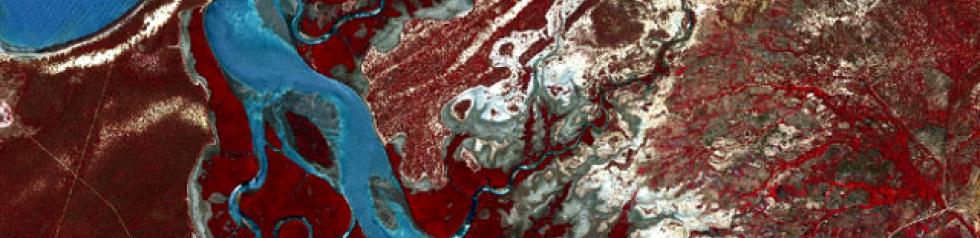
GEOSUD © RapidEye AG 2010, distribution Geosys
Exemple of high resolution national annual coverage acquired by Geosud
Products and services
The Geosud products and services include:
- a satellite data infrastructure in free access for the public players: annual satellite coverages of the national territory in summer at high resolution, imagery on Southern countries, very high resolution images on areas of interest (cities, coasts,…), other images (radar,…)
- a satellite data and services’ infrastructure dedicated to the scientific community (data management and computing equipments: scientific software, remote-controlled computing capacity…) and connected to the Géoportail and the PTSC portal,
- products for methodological and thematic researches on (1) the upstream processing of satellite data flows and (2) on methodological syntheses by large thematic fields. EQUIPEX will contribute to developing national products of interest for research and the management of the environment and territories (the mapping of farmland use, landscape mapping, the mapping of riverside wildlife corridors…),
- actions to support the networking of the scientific community and the interested public players (website, annual events, thematic working groups, methodological syntheses, training strategy).
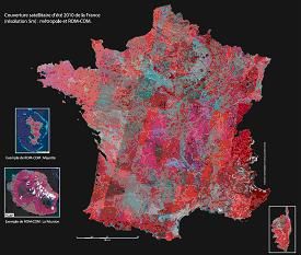
To date the annual coverage of the national territory was acquired at a 5m-resolution in 1997 (IRS data), in 2009, 2010 and 2011 (Rapid Eye data), in 2005 and 2011-2012 (Spot data). Images on specific regions at specific dates were acquired as well.