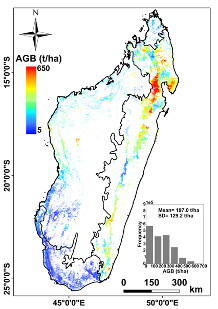
Biomasse à 250 m
Produit de démonstration dont les caractéristiques sont :
Données : données LiDAR spatial, optiques et d’autres jeux de données climatiques.
Résolution : 250m
Couverture : Madagascar
Licence : Etalab2.0
Référence :
- Hajj, Mohammad E., Nicolas Baghdadi, Ibrahim Fayad, Ghislain Vieilledent, Jean-Stéphane Bailly, and Dinh H.T. Minh 2017. « Interest of Integrating Spaceborne LiDAR Data to Improve the Estimation of Biomass in High Biomass Forested Areas » Remote Sensing 9, no. 3: 213. doi: 10.3390/rs9030213