
Data access
As the catalogue is currently experiencing harvesting difficulties that affect the quality of the data, we advise you to use the theia.cnes.fr interface.
Level 2A (single-date)
Level 3A (single-date)
L2A Reflectance
Theia produces and distributes level 2A data, corrected for atmospheric effects thanks to the MAJA software developed in coordination between CNES/CESBIO and DLR. This processor uses multi-temporal information to detect clouds (and cloud shadows) and to estimate the optical properties of the atmosphere. Data are available for all red areas.
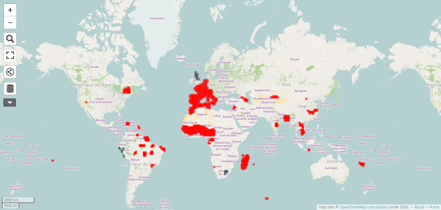
See updated map in full screen
For more information: www.cesbio.ups-tlse.fr/multitemp/?p=6050.
The CNES MUSCATE production center uses MAJA processor to produce in near-real time the Sentinel-2 data acquired on large areas shown here.), whereas the DLR will produce Germany area and distribute it through code-de.
L3 Reflectance
Level 3A products for Sentinel-2 are monthly, cloudless, surface reflectance syntheses. The products provide a weighted average of cloud-free observations over a 45-day synthesis period. N3A reflectances are produced every 15th of the month, since July 2017 for France, since August 2019 for Spain, September 2019 for Italy and, since October 2019, for the Maghreb and Western Sahel.
Traditional methods for creating time syntheses often use the “best available pixel” method, which selects for each pixel the date for which the best acquisition conditions are available. This method usually generates a lot of artifacts on the boundary lines between the different dates selected for each pixel. The weighted average method minimizes these artefacts by performing a cloud-free merging of the different dates.
However, with such a method, any undetected clouds will be used in the averaging calculation and will produce erroneous results. This method therefore requires a very good detection of clouds, which is the case for Level 2A products of MAJA.
Five further means to get L2 Data
Theia does not produce global data with MAJA. If your area of interest is outside the areas processed by Theia, five solutions are available to you:
- If you are a French user belonging to a public body, you can request the addition of a zone to the Theia project manager, by arguing it (our capacities to add sites are limited).
- If you are interested in data on Germany, you can use the data produced by the DLR
- You can use the functions for on-demand processing on FIFO with SHIFT
- You can download the SHIFT software and produce the data on your computer hardware github.com/CNES/Start-SHIFT. The level 3A WASP string is also available github.com/CNES/WASP.
- You can ask CAP Gemini to add your site in the areas produced on the DIAS SOBLOO by contacting muscate.sobloo.fr@capgemini.com.
Contact

Olivier Hagolle
CNES|CESBIO
ResearchGate
@O.Hagolle
Contributions
Satellite
Name : Sentinel-2A and Sentinel-2B
Imaging mode : optical
Spectral bands : 13 spectral multibands from blue to mid-infrared
Resolutions : 10 m to 60 m according to spectral bands
Observation capability :
- Swath : 290 km
- Revisit : 10 days (1 satellite) or 5 days (2 satellites)
Coverage :
- Area : France and other areas in the world
- Period : from mid-2015, available starting 2016
For more information see sentinels.copernicus.eu
Level
Level 2A : data ortho-rectified surface reflectance after atmospheric correction, along with a mask of clouds and their shadows, as well as a mask of water and snow
Format
Technical note describing the format of SENTINEL-2 Level 2A products generated by MUSCATE.
MAJA Algorithm Theoretical Basis Document (ATBD)
License
The Sentinel-2 level 2A or 3A data distributed by THEIA are distributed under the ETALAB V2.0 open license, details of which are available here: Français | English.
For any communication based on these data, please comply with the terms and conditions of the license and listed below:”Value-added data processed by the CNES for the Theia www.theia.land.fr data cluster using Copernicus data. The treatments use algorithms developed by Theia’s Scientific Expertise Centres. »