Documenting in essential variables for biodiversity by remote sensing
Global biodiversity is currently going through a major crisis that is degrading ecosystems, their functions and therefore the services they provide to humanity. Its preservation has thus become a central challenge for sustainable development at national, European (Natura 2000 and the Habitats Directive) and international level (Convention on Biological Diversity, 2011-2020). The increasing availability of open access satellite images such as new modes of data analysis can help to achieve biodiversity conservation objectives by strengthening monitoring processes at various spatial and temporal scales. Open and free access to data thus has a direct impact on our ability to measure the impact of anthropogenic pressures, providing new opportunities to predict the consequences of changes at different scales and make mitigation measures more effective.
Essential variables for biodiversity
The concept of essential biodiversity variables (EBVs) is intended to help structure global biodiversity monitoring, as well as to harmonize and standardize biodiversity data from heterogeneous sources, in order to capture a minimum number of critical variables to study, report and manage biodiversity change. Multi-temporal (RS) remote sensing observations are particularly relevant for automatically quantifying habitat loss, degradation and fragmentation. They also make it possible to optimize fi eld data collection by focusing on representative sites, with significantly improved cost-effectiveness ratios. Ten candidate variables derived from spatial remote sensing have recently been identified and referred to as remotely sensed or remotely accessible EBVs (RS-EBVs) (Skidmore et al., 2015, Pettorelli et al., 2016a;).
Among the current challenges to improve the contribution of remote sensing to biodiversity conservation, strengthening multiple collaborative frameworks between remote-sensing scientists, conservation biologists and ecologists is necessary to improve the effectiveness of conservation methodologies and strategies. ■

Samuel Alleaume
INRAE | TETIS
ResearchGate
Contributions FR |EN

Sandra Luques
INRAE |TETIS
Research Gate
@sandra.luques
Contributions
To go further, the Landscape SEC launched in late March 2019 aspires to identify different indicators, including landscape parameters at various scales. By monitoring landscape fragmentation and alteration of natural habitats, these indicators will contribute to biodiversity conservation.
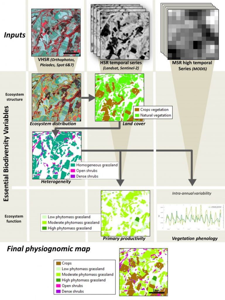
Alleaume S., Dusseux, P., Thierion, V., Commagnac, L., Laventure, S., Lang, M., Féret, J.B., Hubert-Moy, L., Luque, S. (2018) “A generic remote sensing approach to derive operational Essential Biodiversity Variables (EBVs) for conservation planning”, MEE, 9(8) : 1822-1836 DOI 10.1111/2041-210X.13033