Engineer in remote sensing applied to monitoring tropical forest ecosystems
The French National Research Institute for Agriculture, Food, and Environment (INRAE) is a major player in research and innovation. It is a community of 12,000 people with 272 research, experimental research, and support units located in 18 regional centres throughout France. Internationally, INRAE is among the top research organisations in the agricultural and food sciences, plant and animal sciences, as well as in ecology and environmental science. It is the world’s leading research organisation specialising in agriculture, food and the environment. INRAE’s goal is to be a key player in the transitions necessary to address major global challenges. Faced with a growing world population, climate change, resource scarcity, and declining biodiversity, the Institute has a major role to play in building solutions and supporting the necessary acceleration of agricultural, food and environmental transitions.
Work environment, missions and activities
You will be based at the UMR TETIS (Territoires, Environnement, Télédétection et Information Spatiale) in Montpellier, South of France. The lab is part of the “Maison de la Télédétection”, the Integrated Unit TETIS has access to heavy computing resources (storage, high-performance computing) and software used for research and building capacity and teaching activities (GIS, image processing, statistics, etc.). TETIS also produces and/or contributes to numerous IT developments of various kinds and sizes: modelling platforms (generic spatial modelling, radiative transfer models, etc.), data mining applications, multi-sensor image processing chains, GIS plugins, data distribution portals, observatories.
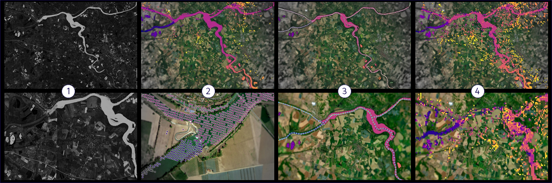
Background: Maintaining and improving the integrity and biodiversity of natural ecosystems is vital for achieving the EU biodiversity strategy for 2030, Sustainable Development Goals (SDGs), and Kunming-Montreal Global Biodiversity Framework. Monitoring progress towards the achievement of the global biodiversity targets requires further development of the adopted monitoring framework and the operationalization of indicators from global to regional level. Biodiversity indicators allow for consistent monitoring of the state of biodiversity, evaluation of the condition of the ecosystems, the services they provide and the drivers of change. The Group on EO Biodiversity Observation Network (GEO BON) has developed a framework for an integrated biodiversity monitoring system under the general concept of Essential Biodiversity Variables (EBVs), and remote sensing (RS) has been proposed as a flagship tool to monitor biodiversity through RS-based EBVs. Within this framework, we work with CNES, France (Centre National d’Etudes Spatiales), on a joint Flagship Action of biodiversity and vulnerable ecosystems to advance Earth System Science and its responses to the global challenges on biodiversity monitoring.
Within this context, a demonstrator focusing on the mapping of forest ecosystems and the biodiversity of Costa Rican forests was set up during the first phase of the project, using data from the Sentinel-2 satellites and spectral diversity mapping methods. This demonstrator, developed as part of the CODEX research project and funded by the TOSCA Programme (CNES), is based on a cloud infrastructure that enables large volumes of data to be accessed, managed and analysed.
The second phase of the project involves deploying this type of approach over a wider range of territories covered by tropical forest ecosystems, notably French Guiana. The context of these areas, in particular the high level of cloud cover, as well as the remarkable levels of diversity, mean that we need to rely on a wider range of sensors, such as radar and hyperspectral imagery, to take better account of this context.
For more information:
Job Summary: Against a backdrop of rapidly evolving digital technologies, particularly in terms of how geospatial data can be accessed and processed on a large scale, you will be involved in the development cycle for the methods and software tools designed as part of the CODEX research project. Opportunity to work on strategic remote sensing projects. A stimulating environment with access to state-of-the-art data and infrastructure.
You will support researchers and engineers in continuing to develop the demonstrator aimed at manipulating Earth observation data from various satellite sensors in the context of monitoring tropical forest ecosystems: multispectral and hyperspectral optics, radar and derived products. You will work closely with the scientists to develop the thematic part and linked to the specificities of integrated imagery, and in liaison with the infrastructure architects to deploy the demonstrator. You will work as part of a team (research, engineering) and contribute to scientific production through the technical aspect, as well as being involved in it (publications, reports, etc.).
Specific conditions of activity:
You will be based at the Integrated Unit TETIS (Territoires, Environnement, Télédétection et Information Spatiale) INRAE, based at the Maison de la télédétection in Montpellier, France.
Training and skills
Master’s degree/Engineering degree
Desired Knowledge & Skills:
- Implement multi-source data fusion methods (optical, RADAR….)
- Optimize processing pipelines to improve the accuracy and speed of analyses.
- Collaborate with experts in remote sensing, artificial intelligence, and computer science to develop innovative solutions.
- Strong expertise in signal processing and signal physics in remote sensing.
- Solid understanding of SAR analysis techniques, including interferometry and polarimetry, is highly valued.
- Strong command of programming languages used in data science, particularly Python and R, along with key libraries (NumPy, Pandas, etc.). Knowledge of other languages is a plus.
- Experience with geospatial libraries (GDAL/OGR, OTB, GeoPandas, PySTAC, xarray, etc.) and machine learning libraries (Scikit-Learn, Keras/TensorFlow, PyTorch, etc.) is appreciated.
INRAE’s life quality
By joining our teams, you benefit from (depending on the type of contract and its duration):
– up to 30 days of annual leave + 15 days “Reduction of Working Time” (for a full time);
– parenting support: CESU childcare, leisure services;
– skills development systems: training, career advise;
– social support: advice and listening, social assistance and loans;
– holiday and leisure services: holiday vouchers, accommodation at preferential rates;
– sports and cultural activities;
– collective catering.