Focus on Theia Snow Product
Theia Bulletin n°11 features a focus on the Theia Snow Product giving the point of view of users as well as the researcher who led its development.
French National Parks Track Snow Cover with Theia
The formulation of the 2018 Satellite Application Plan (SAP) by the French Ministry of Ecological Transition and Solidarity (MTES) and the Ministry of Territorial Cohesion and Relations with Territorial Communities (MCTRCT) has enabled many service needs to be expressed (=>Read Bulletin n°10).
The measurement of snow cover is one of the 20 needs identified (=>www.geoinformations.developpement-durable.gouv.fr/plan-d-applications-satellitaires-2018-r1016.html) – a demand steered by the Vanoise National Park. In addition to monitoring glacier retreat, the Vanoise National Park as well as the Écrins National Park use satellite imagery as part of the Sentinel Alpine Pasture programme which aims to determine the evolution of mountain pastures in relation to climate change (date of snowmelt and availability of grass).
Other national parks, in particular Mercantour Park, are also interested in this issue, particularly for the monitoring of certain animals, like the mountain hare and the ptarmigan. Measuring the extent of snow cover and its retreat makes it possible to monitor these species and anticipate their movements.
and to simplify the use of Theia data for actors in the field.
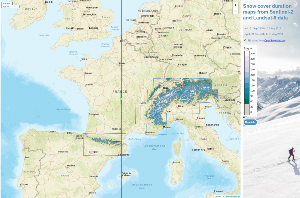
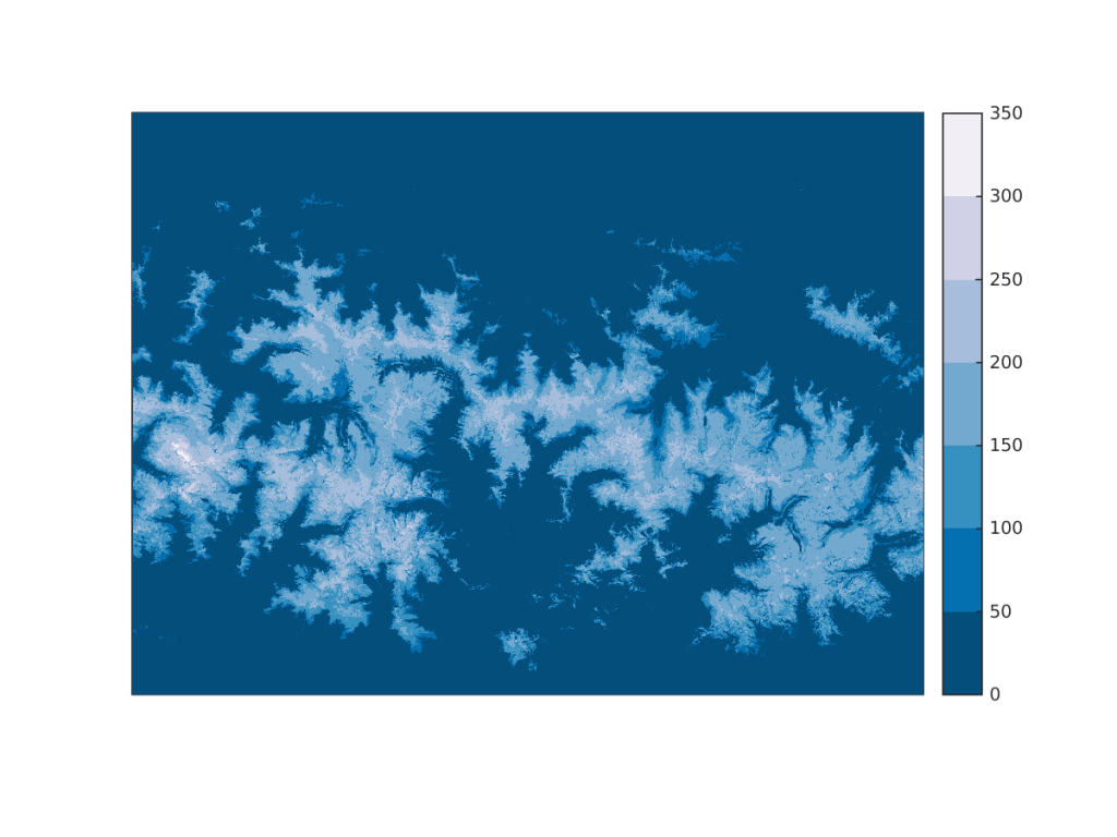
osr-cesbio.ups-tlse.fr/echangeswww/majadata/simon/snowMaps.htm
The advantage of the Theia snow product
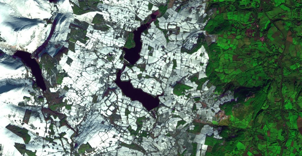
In the overall perspective of implementing 2018 SAP, the MTES Geographic Information Mission (MIG) has established relationships with Theia and identified an existing product that addresses this snow cover issue. Maps are produced from Sentinel-2 images with a 5-days frequency and a 20 m resolution. The legend is: snow, no snow, clouds. Maps are available four days after the capture. They are free and accessible on Theia’s website. The results obtained are very good even if there are still two difficulties, namely distinguishing snow from clouds and detecting snow in dense forests.
In order to promote the reuse of this application, which is already operational, the Vanoise National Park, with the support of the MIG, organised a meeting with interested users, the CNES and the Theia consortium. This exchange session was held on 23 March in Chambéry at the Vanoise National Park. In addition to the Vanoise Park, the Mercantour National Park, the Pyrenees National Park, several DDTs (15, 62, 74) and the Syndicat mixte d’aménagement de la vallée de la Durance (SMAVD) have also expressed their needs.
Identifying uses and needs
The participants discovered the pooled opportunities of the tool developed by Theia and shared their own practices and expectations. Several uses were presented: better knowledge of water resources in a massif, snow-covered trails at a given date, regular monitoring of snow cover in ski resorts, flood risks.
Participants listed expectations: snow duration maps, measurement of snow-covered areas, estimation of water stocks (planned), high frequency snow removal dates, snow-cultivation dynamics, climate change indicators, supply only of the snow mask, delivery format (raster or vector?), tile assembly (WMS flow), several download options, user training.
The participants also agreed to complete an inventory of uses and needs, and to open it up to other potentially interested actors: basin agencies, other national parks, DDT in mountain ranges, SHAPI, etc.
MIG will also provide stakeholders with a shared space to gather user needs (document prepared by the Vanoise National Park available at: lite.framacalc.org/iu7tFlCwqr), documents (presentations, guides) and a discussion tool (forum).
Measuring Snow Cover: a Challenge Met and Recognized
Interview with Simon GASCOIN
Snow-covered surface SEC
What is the history and specificity of the Snow Product available on Theia?
Simon Gascoin: The operational production of the Theia Snow Product started at the end of 2017. Before that, we generated many products on Cesbio’s calculation servers, and then there was a first production phase on a batch of Sentinel-2 images by MUSCATE at CNES to test the processing line under operational production conditions.
For the most part, the algorithm and product were defined in 2015 from SPOT-4 Take 5 series on the Pyrenees and Atlas. Little has changed since then, but the parameters have been adjusted. Theia Snow Product mainly benefits from improvements in the level 2A treatment chain upstream.
There is no equivalent product to date. The USGS distributes maps of snow-covered areas from Landsat data, but this is not a continuous production and, most importantly, these maps do not offer the repetitiveness of Sentinel-2. Our map reports the presence or absence of snow and not the snow fraction per pixel. In my opinion this product is easier for users to adopt, even if the snow fraction is more informative theoriticaly.
This product is the result of teamwork: at CNES, Manuel Grizonnet, Cesbio, Olivier Hagolle and Simon Gascoin, Magellium, Germain Salgues. Manuel has changed departments and will be replaced by Aurore Dupuis at CNES. But we must also mention the whole MUSCATE team, without forgetting Arnaud Sellé and Nicolas Bagdhadi for the coordination of Theia, as well as Sophie Ayoubi and Isabelle Biagiotti for communication!
You have just participated in a European call for tenders that includes a “Snow” dimension. How did the existing Theia Snow Product contribute to the success of the proposal?
Simon Gascoin: We had worked with the company Magellium in the development of the treatment chain. It was natural to continue to work with them to respond to a European call for tenders to map in real time the snow- and ice- covered areas with Sentinel-2 on a European scale on behalf of the European Environment Agency under the Copernicus programme.
Thanks to Theia we had a clear demonstration that our system was operational on a large scale. The development of the Theia product has also pushed us to maintain the code and its documentation as the level 2A data evolves. At a Theia meeting someone asked me if I had done an evaluation of the Theia snow product with in situ measurements. At first I was not convinced of the interest of this comparison because I preferred to validate visually or with other higher resolution remote sensing images. But this question prompted me to make a comparison with data from Météo-France stations. In addition to its scientific interest, I think that this work has paid off because it was an explicit request from the call for tenders, and we have therefore been able to show very encouraging results in this respect.
What is the future of the Snow Product?
Simon Gascoin: Many users need to condense the information provided by snow maps and are bothered by clouds in their analyses. In addition, Theia Snow Product is only available on the date of the satellite’s passage. We would therefore like to offer an on-demand service that allows us to obtain a map of the snow cover duration per pixel of 20 m for a user-defined period regardless of the satellite’s passage date.
This service would solve these two obstacles and thus broaden the user community. A demonstrator is available here:
www.cesbio.cnrs.fr/multitemp/?p=14620.

Simon Gascoin
CNRS | CESBIO
@S.Gascoin
Contributions
Read the New Theia Bulletin
>>> Read on-line on Calaméo