Sentinel-2B delivers its first images
Just over a week after being lofted into orbit, the European Union’s Sentinel-2B satellite delivered its first images of Earth, offering a glimpse of the ‘colour vision’ it will provide for the Copernicus environmental monitoring programme.
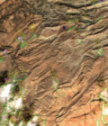
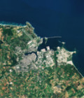
With a swath width of 290 km, the satellite’s first acquisition began over the Baltic Sea and made a strip-like observation through eastern Europe, ending in northern Libya.
The data were relayed in real time to the Matera ground station in Italy, where the images were then processed.
While eastern Europe was mostly cloudy, Italy’s sunny skies allowed the teams to get their first glimpse of the multispectral instrument’s capabilities over southern Italy’s Calabria and Apulia regions.
For more information see esa.int
More information: Sentinel-2