SWOT : Understanding Our Rivers, Lakes and Floodplains
The Mission Status
The SWOT (Surface Water Ocean Topography) mission is the result of over three decades of collaboration between NASA and CNES. The partnership began with the TOPEX/Poseidon altimetry mission in 1992, followed by the Jason-1/-2/-3 missions, and culminated in the launch of SWOT in December 2022, in collaboration with the UK Space Agency (UKSA) and the Canadian Space Agency (ASC/CSA). In addition to a conventional nadir altimeter, SWOT is equipped with a Ka-band interferometric radar (KaRIn), imagined by Ernesto Rodriguez of the Jet Propulsion Laboratory (JPL), and representing a technological and scientific breakthrough. SWOT is the first satellite mission primarily dedicated to mapping water surface elevations for both oceanic and hydrological applications on a global scale. The SWOT satellite, now in orbit for more than two years, began delivering valuable data as soon as the KaRIn instrument was activated. After spending three months on a calibration/validation (Cal/Val) orbit (data available from March 30 to July 11, 2023), it transitioned to its nominal “science phase”orbit on July 26, 2023. Today, the satellite is performing under excellent conditions.
Continental Water Products
The SWOT products for continental waters are available at various levels of complexity, as described below, depending on the user’s needs and expertise. Additional details can be found in the product description documents.

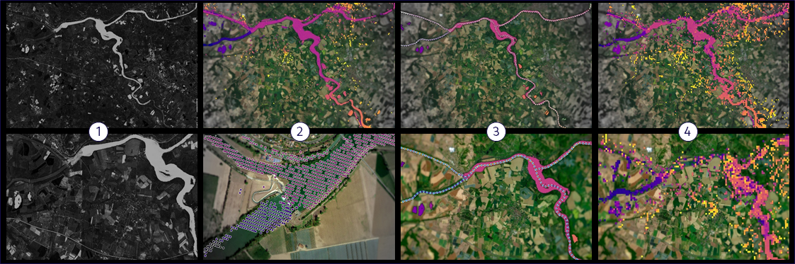
Illustration of the main SWOT HR products for continental hydrology. 1 – SLC image, 2 – PIXC/PIXCVec, 3 – RiverSP/Average and LakeSP/Average, 4 – Raster products.
Single Look Complex Product: For each of the two receiving antennas of KaRIn, and for each swath (right and left) time-domain synthetic aperture radar (SAR) processing of the ordered HR telemetry data yields single look complex (SLC) products. The SLC images are provided with a posting of ~3 m along-track, and varying from ~70 m to ~10 m cross-track in the nominal swath (10-60 km from nadir). Pixel Cloud Product: Multilooking, water detection, phase unwrapping and numerous other processing steps applied to the SLC data result in the pixel cloud (PIXC) product, which is a sparse representation of the computed water mask, with geolocated heights (w.r.t. the WGS84 ellipsoid), geophysical corrections and quality indicators. The along-track posting is ~22 m.
Height (m) of pixels from the L2_HR_PIXC product over the Rhine River.
River Single Pass and Average Product: The high-resolution PIXC data are aggregated into separate vector products for rivers and lakes. The single-pass river (RiverSP) product provides measurements of water surface elevation (w.r.t. to the EGM2008 geoid), width and area for nodes defined at ~200-m intervals, as well as reaches defined at 5-20-km intervals, along centerlines provided by the SWORD river database. River slope and estimates of discharge are also computed for river reaches. The RiverSP products are aggregated over each 21-day cycle to obtain RiverAvg products with cycle-average water surface elevations, slopes etc.
Lake Single Pass and Average Product: Similarly, single pass lake (LakeSP) products are obtained by intersecting (non-river) water features in PIXC products with the lake polygons of the Prior Lake Database (PLD). For each lake they contain average water surface elevation, water surface area, and derived estimates of storage change. Lake average (LakeAvg) products are obtained by aggregating LakeSP products over a 21-day cycle.
Pixel Cloud Vector Product: The pixel cloud vector (PIXCVec) product is a companion product to the PIXC product, containing additional information obtained during RiverSP and LakeSP processing, in particular height-constrained (further regularized) geolocations and river (SWORD) and lake (PLD) identifiers.
Raster Product: As PIXC and PIXCVec are point clouds with irregular latitude/longitude posting, an additional product is generated that should be easier to use, at the cost of lower resolution: The Raster product provides rasterized water surface elevation, water fraction, area etc., on regular grids with a posting of 100 or 250 m.
Status of Products Reprocessing
Each day, the ground segment processes approximately 20 TB of data, which is made publicly available within five days of being collected by the satellite. The first version of SWOT data usable by the scientific community (Version C) was released by NASA and CNES in March 2024. In June 2024, the SWOT Science Team confirmed that data available since February 2024 could be considered valid. The algorithms and auxiliary data used to generate the various SWOT products continue to improve. In October 2024, the PIC2 version of the products was put into production, replacing the earlier PIC0 version. An even more significant set of updates will be introduced soon with the release of the PID0/PGD0 version. This new, more precise version will be made available progressively, and a full reprocessing of all “D0” level data from the start of the mission will be carried out, with the reprocessed data expected to be available to users by fall 2025. A document outlining the main improvements will be released soon. Additionally, there has been a major overhaul of the SWOT River Database (SWORD), including a complete renumbering of river segments and nodes, which users will need to account for.
Regarding the “progressive” production of data, a significant portion of HR products have not been generated since mid-October 2024 due to an infrastructure issue at the mission center. A reduced production mask has been implemented to prioritize key areas, including Cal/Val sites. Missing data will be addressed during the 2025 reprocessing campaigns. The 2024 reprocessing campaign (Version PGC0), covering data from late March 2023 to January 2024 has been completed. The 2025 reprocessing campaign (Version PGD0), covering the period from late March 2023 to February 2025, is set to begin shortly, starting with the Cal/Val period. These improved HR products will be made available progressively, starting in May. Despite occasional challenges due to the complexity and volume of data, the ground segment continues to fulfill its mission successfully overall.
Validation and Field Work
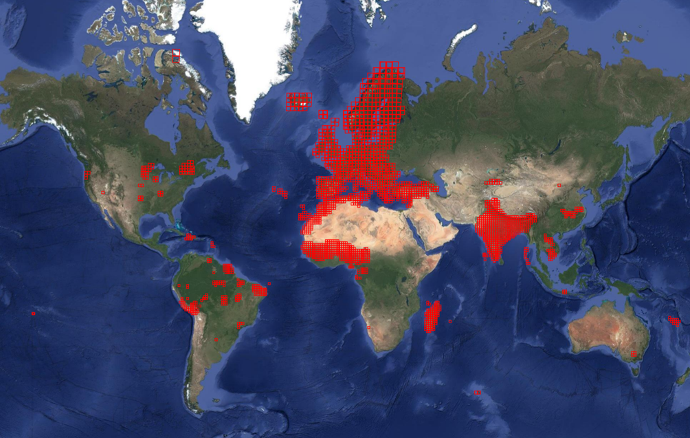
The KaRIn interferometer onboard SWOT is an innovative instrument designed to measure the topography of water surfaces with unprecedented spatial resolution. However, the detection of water body edges remains uncertain, and measurement errors in altitude can be locally significant. Therefore, validating the altimetric data derived from radar measurements is crucial. Extensive calibration and validation efforts have been undertaken, based on collected in situ hydrometric measurements conducted specifically for the SWOT mission. These measurements were performed at selected sites covering a wide variety of environments and climates, from the banks of the Garonne River to frozen Canadian lakes and the Amazon River. Validation efforts included using a geodetic calibration carpet towed by boat over the floodplains of Lago Curai in the Brazilian Amazon, as illustrated in the figure (credits SGB/IRD/CNES). The collected measurements allow the validation of SWOT water heights and slopes, help quantify errors and better understand their origins. They also highlight the remarkable accuracy of SWOT data, as demonstrated by a profile along a section of the canalized Rhine in Alsace.


Analysis and validation of free-surface elevation data from SWOT: pixel cloud in blue and RiverSP at node level in orange on the Rhine, compared to ground data (red). (Credit: CNES/SERTIT/CS).
River Discharge
River discharge varies in a complex, nonlinear manner, depending on its depth – and therefore also on the water surface elevation measured — its width, and other unmeasurable parameters. Estimating discharge from altimetric observations is a significant challenge, particularly without knowledge of other parameters describing the river itself and the local flow physics (such as energy dissipation due to the shape and nature of the riverbed). The SWOT mission’s Science team, especially the Discharge Algorithms Working Group (DAWG), has developed approaches to estimate discharge over river reaches. These methods, based on hydraulic models, estimate SWOT discharge product. A computational platform named “Confluence” runs the discharge algorithms globally and produces estimates of the necessary parameters to produce the mission product. This product provides unprecedented spatial density, enabling the study of spatial patterns of river discharge for the first time. The quality of the estimated discharge depends on a range of uncertainties, such as the accuracy of known local average values and observational errors. Research is ongoing to improve both data processing methods and discharge estimation algorithms.

<Description of the illustration> Example of SWOT discharge estimates for five satellite passes (panels a-e) and the average across all passes during the nominal phase (07/21/2023–07/21/2024, panel f) for 654 river reaches in the Ohio River basin, USA (Credit DAWG).
To obtain a complete daily time series, it is possible to densify the observations in both space and time. A range of approaches has been implemented. Among these, assimilating SWOT observations into a hydraulic (or routing) model allows for simulating a more comprehensive state of the river system by accounting for flow dynamics in the network. Coupled systems combining hydraulic or routing models with hydrological models have been developed, integrating data assimilation methods to reconstruct missing dynamics in time and space based on SWOT data and modeled dynamics. Several coupled systems exist and have been validated through controlled experiments at local full network of basins (e.g. MGB-DassFlow-1D by INRAE, Hydro Matters, CS and SIC-RAPID by INRAE/JPL) or global scales (e.g. CTRIP-HyDAS by Météo France). These efforts aim to produce the first hydrological reanalysis based on SWOT in the near future.
Lakes Water Storage
SWOT provides, for the first time, a nearly global inventory of all lakes and reservoirs measuring at least 250mx250m (and potentially much smaller, depending on observation conditions), along with the temporal dynamics of their volume variations. Using SWOT observables – namely, water surface elevation and water extent at the satellite’s overpass- it is possible to estimate changes in lake volume relative to a reference date. This is achieved by leveraging successive satellite observations and assuming a simplified bathymetry. These volume variation estimates will be directly included in the future version of the SWOT LakeSP product.

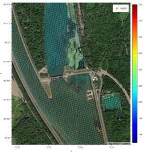
An example of SWOT data collected daily over the Lake Gérardmer during the Cal/Val period (April 1st, 2023- July 1st, 2023) that are used to compute the water volume variations.
The accuracy of these estimates depends on the quality of all SWOT observables, particularly the water extent mask; lake volume variations will be calculated using two different methods with adequate equations, allowing users to choose the most suitable option. In most cases, the differences between these methods are minimal, as demonstrated by simulations conducted at CNES before the satellite’s launch.
Date Access and Use : Best Practices
Several fully open and free access points are available for SWOT hydrological data, catering to different user profiles and needs:
- Hydroweb.next Portal : Managed by Terra/Theia hub, this portal is designed for hydrologists. It allows users to download SWOT-HR Level 2 data a,d other hydrological datasets via a web interface or API. It also provides visualisation tools, including interactive maps and time-series graphs for lakes and river segments. To access all SWOT product collections, simply enter “SWOT” in the search bar.
- NASA/JPL/PO.DAAC Portal : This portal provides access to SWOT Level 1b and SWOT HR Level 2 data, which can be downloaded via a web interface or API. Additionally, the hydrocron API is available for extracting SWOT time series for specific lakes or river segments.
- SWOTViz Portal : Developed by the CUAHSI consortium (US. universities), this portal offers graphical visualization of SWOT time-series data for lakes and river segments. It is specifically designed for hydrologists conducting this type of analysis.
- HAWK : For advanced users, CNES provides this expert platform, accessible on request to members of the SWOT Science Team and collaborative projects with CNES. This environment offers a wide range of tools and tutorials for analyzing and utilizing SWOT data. It also includes a database of SWOT river, lake and in-situ products, facilitating data search, processing and validation on a global scale.
Additionally, an extensive set of open-source tools and tutorials is available to assist users in working with SWOT products. These resources can be accessed on GitHub SWOT-community and the associated website SWOT Hydrology Galleries.
Currently, there are 12 SWOT product collections dedicated to hydrology. Each collection is designed for a specific type of user, ranging from satellite data experts to hydrologists. We strongly recommend that users carefully review the available documentation on the data portals, particularly the SWOT Data User Handbook, to determine which collections best suit their needs. The documentation also provides guidance on the proper use of these products, detailing the various geophysical variables available and their associated quality indicators. Non-experts in remote sensing may find SWOT-averaged products more useful, such as RiverSP (averaged along river reaches) and LakeSP and Unassigned (averaged over lake and reservoir extents). However, identifying error sources in SWOT observables is more challenging in these products. Users should not assume that SWOT data is unreliable for a given date without first checking the quality flags and, if needed, referring to less processed products like the PixC point cloud and gridded raster products.
SWOT & Education
Beyond scientific contributions, the SWOT mission offers significant opportunities for collaboration between the scientific and educational communities, fostering climate education and promoting space sciences. In this context, the Office for Climate Education (OCE) – a key institutional player within the United Nations framework – is leading initiatives to advance high-quality education on oceans continental water and climate change in primary and secondary schools. One such initiative is the reproduction of an educational guide, providing teachers with a ready-to-use manual to explore the role of oceans in climate regulation, the ecosystem services provided by oceans, continental waters and the cryosphere, as well as the effects of climate change. The updated guide will include a new lesson on monitoring oceans and continental waters using SWOT, further enriching climate education in classrooms.
First Scientific Publications on Inland Waters After Launch
Year: 2024
Fu LL, Pavelsky T, Cretaux JF, Morrow R, Farrar JT, Vaze P, Sengenes P, Vinogradova‐Shiffer N, Sylvestre‐Baron A, Picot N, Dibarboure G. The surface water and ocean topography mission: A breakthrough in radar remote sensing of the ocean and land surface water. Geophysical Research Letters. 2024 Feb 28;51(4):e2023GL107652.
Salameh, E., Desroches, D., Deloffre, J., Fjørtoft, R., Mendoza, E. T., Turki, I., Froideval, L., Levaillant, R., Déchamps, S., Picot, N., Laignel, B., Frappart, F. Evaluating SWOT’s interferometric capabilities for mapping intertidal topography, Remote Sensing of Environment, vol. 314, p. 114401, DOI: 10.1016/j.rse.2024.114401.
López Weibel, C., Walker, E., Szupiany, R., Venturini, V., Segura Ellis, J., Oberg, K., García, C.M., Diaz Lozada, J.M., Zaffaroni, P., Jobbagy, E., Minear, T. Evaluation of SWOT Water Surface Elevation Product Along the Middle Paraná River, 2024 IEEE Biennial Congress of Argentina (ARGENCON), San Nicolás de los Arroyos, Argentina, 2024, pp. 1-5, doi: 10.1109/ARGENCON62399.2024.10735715.
Hamoudzadeh A, Ravanelli R, Crespi M. SWOT Level 2 Lake Single-Pass Product: The L2_HR_LakeSP Data Preliminary Analysis for Water Level Monitoring. Remote Sensing. 2024 Mar 31;16(7):1244.
Yu, L., Zhang, H., Gong, W. and Ma, X., 2024. Validation of Mainland Water Level Elevation Products from SWOT Satellite. IEEE Journal of Selected Topics in Applied Earth Observations and Remote Sensing.
Normandin, C., Frappart, F., Baghdadi, N., Bourrel, L., Peña Luque, S., Ygorra, B., Kitambo, B., Papa, F., Riazanoff, S. and Wigneron, J.P., 2024. First results of the surface water ocean topography (SWOT) observations to rivers elevation profiles in the Cuvette Centrale of the Congo Basin. Frontiers in Remote Sensing, 5, p.1466695.
Getirana, A., Kumar, S., Bates, P., Boone, A., Lettenmaier, D. and Munier, S., 2024. The SWOT mission will reshape our understanding of the global terrestrial water cycle. Nature Water, 2(12), pp.1139-1142
Year: 2025
Laipelt, L., de Paiva, R.C., Fan, F.M., Collischonn, W., Papa, F. and Ruhoff, A., 2025. SWOT reveals how the 2024 disastrous flood in South Brazil was intensified by increased water slope and wind forcing. Geophysical Research Letters, 52(2), p.e2024GL111287.
Konstantinos M. Andreadis, Steve P. Coss, Michael Durand, Colin J. Gleason, Travis T. Simmons, Nikki Tebaldi, David M. Bjerklie, Craig Brinkerhoff, Robert W. Dudley, Igor Gejadze, Kevin Larnier, Pierre-Olivier Malaterre, Hind Oubanas, George H. Allen, Paul D. Bates, Cédric H. David, Alessio Domeneghetti, Omid Elmi, Luciana Fenoglio Marc, Renato Prate de Moraes Frasson, Elisa Friedmann, Pierre-André Garambois, Jaclyn Gehring, Augusto Getirana, Marissa Hughes, Jonghyun Lee, Pascal Matte, J. Toby Minear, Jérôme Monnier, Aggrey Muhebwa, Mohammad J. Tourian, Tamlin M. Pavelsky, Ryan M. Riggs, Ernesto Rodríguez, Md Safat Sikder, Laurence C. Smith, Cassie Stuurman, Jay Taneja, Angelica Tarpanelli, Jida Wang, Brent A. Williams, Bidhyananda Yadav, “A first look at river discharge estimation from SWOT satellite observations”. Manuscript under review Geophysical Research Letters.
Han X., Zhang G., Crétaux J.-F., Wang J., Schwatke C., Peng M., Allen G. H., Wang X., Shum C. K., Woolway R. I., Ke Y., Zhou T., Xu F. Reconstructing small lake dynamics on the Tibetan Plateau using gap-filled SWOT data. (In preparation).
SWOT Science Team Members
France :
| Hydrology | Hind Oubanas | Jean-François Crétaux | Sylvain Biancamaria | Fabrice Papa |
| Sophie Ricci | Pierre-Olivier Malaterre | Jérôme Monnier | Pierre-André Garambois | |
| Adrien Paris | Hervé Yésou | Kévin Larnier | Marielle Gosset | |
| Pedinotti Vanessa | Frédéric Frappart | Kouarev Alexei | Aaron Boone | |
| Simon Munier | Catherine Ottle | Manuela Grippa | ||
| Oceanography | Francesco d’Ovidio | Rosemary Morrow | Pascal Bonnefond | Andrea Doglioli |
| Lionel Gourdeau | Frederic Marin | Sophie Cravatte | Julien Le Sommer | |
| Emmanuel Cosme | Pierre-Yves Le Traon | Mounir Benkiran | Isabelle Dadou | |
| Aurélien Ponte | Lionel Renault | Emmanuel Dormy | Michael Ablain | |
| Gerald Dibarboure | Guillaume Lapeyre | Alex Ayet | Adrien Martin | |
| Eva Le Merle | Frédéric Nouguier | Fabrice Ardhuin | Lotfi Aouf | |
| Alice Dalphinet | Marie Isabelle Pujol | Gaël Alory | Ludivine Oruba | |
| Ariane Koch-Larrouy | Camila Artana | Fabrice Hernandez | ||
| Estuaries/Coastal | Nadia Ayoub | Imen Turki | Benoit Laignel | Florent Lyard |
| Cryosphere | Sara Fleury |
United States :
| Tamlin Pavelsky | Tom Farrar | Brown, Shannon | Callies, Joern |
| Cooley, Sarah | David, Cedric | de Figueiredo Melo | Villas Boas, Ana |
| Villas Boas, Ana | Beatriz | Durand, Michael | Feng, Dongmei |
| Foukal, Nicholas | Giddings, Sarah | Gille, Sarah | Gleason, Colin |
| Hossain, Faisal | Kumar, Sujay | Minear, J Toby | Nerem, Robert |
| O’Donnell, Frances | Passalacqua, Paola | Pieper, Kelsey | Qiu, Bo |
| Sandwell, David | Shcherbina, Andrey | Simard, Marc | Smith, Kendall |
| Smith, Laurence | Snow, Tasha | Stopa, Justin | Thompson, Andrew |
| Wang, Jida | Whitt, Daniel | Zaron, Edward | Verdy, Ariane |
| Webb, Elizabeth | Yu, Yao | Abrahams, Ellianna | Das, Pritam |
| Andreadis, Konstantinos | Brinkerhoff, Craig | Frasson, Renato | Lamb, Michael |
| Rowley, Taylor | Getirana, Augusto | Coss, Stephen | Ray, Richard |
| Badarvada, Yadidya | Biswas, Nishan Kumar | Cook, Salme | Eldardiry, Hisham |
| Ganju, Neil | Gilmour, Morgan | MacCready, Parker | Mambela, Judy Emmanuel |
| Padman, Laurence | Seaton, Charles | Vannan, Suresh | Balwada, Dhruv |
| Beck, John | Bodner, Abigail | Brantley, Steven | Buijsman, Maarten |
| Chassignet, Eric | Hell, Momme | Johnson, Leah | Jones, C Spencer |
| Lenain, Luc | Menemenlis, Dimitris | Piliouras, Anastasia | Pollock, Kydd |
| Raymond, Peter | Schwenk, Jon | Shen, Chaopeng | Shriver, Jay |
| Stuurman, Cassie | Zaron, Edward | Akella, Santha | Allen, George |
| Beighley, Edward | Brown, Casey | Chae, Chun Sik | Chapron, Bertrand |
| Christensen, Alexandra | Cornuelle, Bruce | Denbina, Michael | Foster, Ralph |
| Gao, Huilin | Garner, Megan | Arbic, Brian | Howard, Susan |
| Jones, Charles | Kelly, Samuel | Klein, Patrice | Leach, James |
| Bhuyan, Mohamad | Nie, Wanshu | Mazloff, Matthew | Menemenlis, Dimitris |
| Minear, J Toby | Rodriguez, Angelica | Ryan, Svenja | Siegelman, Lia |
| Siegfried, Matthew | Torres Gutierrez, Hector | Vandemark, Douglas | Xu, Xiaobiao |
| YOON, YEOSANG | Zhang, Weifeng | Zhou, Tian | Carrere, Loren |
| Gopalakrishnan, Ganesh |
International :
| Daniel Moreira | Mélanie Trudel | Neal Jeffrey | Paul Bates |
| Chander Shard | Seehaus Thorsten | Tourian Mohammad J. | Makan Karegar |
| Schöne Tilo | Alexander Zubovich | Alfredo Netto | Duguay Claude |
| Grant Gunn | Carmona-Moreno Cesar | Kusche Jürgen | Döll Petra |
| Schwatke Christian | Sneeuw Nicolaas | Luciana Fenoglio-Marc | Amadou Abdourhamane Touré |
| Dai Yamazaki | Pascal Matte | Takaya Uchida | Antonio Bonaduce |
| Ole Andersen | Christine Gommenginger | Francisco Calafat | Félix Muller |
| Ichikawa Kaoru | Shane Keating | Ananda Pascual | Neeraj Agarwal |
| Laura Ruiz-Etcheverry | Martin Saraceno | Xiaoli Deng | Paul Bell |
| Luciana Fenoglio | Joanna Stavena | Pein Johannes | Takeshi Izumo |
| Marania Hopuare | Marcello Passaro | Denise Dettmering | Stelios Mertikas |
| Han Guoqi | Will Perrie | Hannah Charles | Michael Hart-Davis |
| Christian Schwatke | Christopher Watson | Clara Lazaro | Joana Fernandes |
| James Colliander | Susantha Jayasinghe | Denise Dettmering | Mohammed Dabboor |
| Rosemary Willatt |
Contacts
River Discharge and Water Volume Products:
- Questions about the river discharge product:
Pierre-Olivier Malaterre (pierre-olivier.malaterre@inrae.fr) and Kévin Larnier (kevin.larnier@hydro-matters.fr) - Questions about the water volume product:
Jean-François Cretaux (Jean-Francois.Cretaux@cnes.fr) and Claire Potier (Claire.Pottier@cnes.fr)
Data Access
- THEIA Support: exp.hysope2@cnes.fr
- CNES Support: Mathilde Simeon & Julien Petiton (swot_ce@cnes.fr)
Useful Links
- SWOT Data User Handbook : https://archive.podaac.earthdata.nasa.gov/podaac-ops-cumulus-docs/web-misc/swot_mission_docs/D-109532_SWOT_UserHandbook_20240502.pdf
- PO.DAAC Cookbook : https://podaac.github.io/tutorials/quarto_text/SWOT.html
- Hydrocron : https://podaac.github.io/hydrocron/intro.html
Contributors
| Hind Oubanas | Delphine Leroux | Christophe Marechal |
| Nicolas Picot | Roger Fjørtoft | Claire Pottier |
| Sylvain Biancamaria | Jean-François Cretaux | Francesco D’Ovidio |
| Lionel Zawadzki | Mathilde Simeon | Pierre-Olivier Malaterre |
| Pierre-André Garambois | Jérôme Monnier | Kévin Larnier |
| Simon Munier | Fabrice Papa |