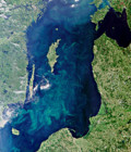
Remote Sensing of the Coastal Zone : EARSel workshop
The 7th EARSeL Workshop on Remote Sensing of the Coastal Zone will take place at the Royal Institute of Technology Stockholm, Sweden from 17th to 19th June 2015
The Workshop will provide an interdisciplinary forum for presentations and discussions of our current state of knowledge on remote sensing of the coastal zone environment in terms of algorithms accuracy, time series analysis of environmental indices based on remote sensing data, and new technologies. These topics will emphasize the impact of the climate variability on the European Sea with particular emphasis on coastal zones and inland waters highlighting the importance of measuring essential climate variables which can exhaustively describe the status of the coastal environment.
More information on the 7th EARSeL Workshop on Remote Sensing of the Coastal Zone