clASpy_T : a 3D point cloud classification tool for estuary monitoring
The THEIA portfolio of Lidar data processing tools has been extended with a new software tool for creating 3D point cloud classification models using machine learning: cLASpy_T
cLASpy_T aims to help design machine learning models directly applicable to LAS data. It is entirely developed in Python and offers two user interfaces: a command-line interface and a graphical interface. It manages data formatting to be compatible with the scikit-learn API. It saves machine learning models, saves point cloud classification results directly in LAS format and provides a detailed report for each task performed.
Today, cLASpy_T is actively supported by the M2C laboratory and the SCIENTEAMA company, who wish to enhance the software by adding other data formats, such as GEOTIFF or PLY, as well as other machine/deep learning libraries such as TensorFlow or PyTorch.
A tool dedicated to estuaries
The development of cLASpy_T is in line with current research initiatives aimed at monitoring the evolution of coastal landscapes under economic, residential and tourist pressure. Lidar data offer significant potential for monitoring natural environments and human impacts.
cLASpy_T was developed as part of the AUPASED project (OFB funding 2018-2021). It has demonstrated its ability to automate sediment mapping in estuaries, with various examples in La Manche.
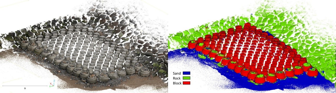
cLASpy_T has since been used to demonstrate the usefulness of machine learning models for automatically extracting concrete blocks from coastal protection dykes. It has also contributed to the CHERLOC project, funded by the ERDF and the Normandy Region, to study the ecological and social impact of anti-submergence equipment on coastal sites.