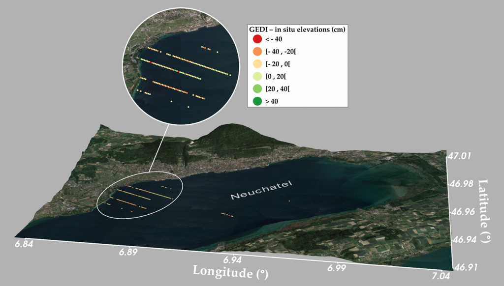
First evaluation of GEDI’s measurement quality for the monitoring of water levels
The recent LiDAR altimetry mission of Nasa’s Global Ecosystem Dynamics Investigation (GEDI) instrument, offers the capability to provide billions of high-quality altimetry measurements worldwide.
A first study, carried out at TETIS, evaluated the accuracy of GEDI elevation measurements for the estimation of lake water levels. The difference between GEDI elevation estimates and water levels from hydrological gauges was evaluated for eight lakes in France and Switzerland.
GEDI elevation estimates show good agreement with gauge water level readings, with a mean elevation difference of 0.61 cm and a standard deviation of 22.3 cm. Over the eight studied lakes, the mean difference between GEDI elevations and in situ readings ranged from -13.8 cm to +9.8 cm with a standard deviation of the mean difference ranging from 14.5 to 31.6 cm. The precision of these estimates could be increased to 8.5 cm (standard deviation) by modeling the instrumental and environmental factors partly responsible for this variation.
Read the whole publication:
Fayad I., Baghdadi N., Bailly J.S., Frappart F., Zribi M., 2020. Analysis of GEDI Elevation Data Accuracy for Inland Waterbodies Altimetry. Remote Sensing, Remote Sens. 2020, 12, 2714; doi:10.3390/rs12172714. https://www.mdpi.com/804846