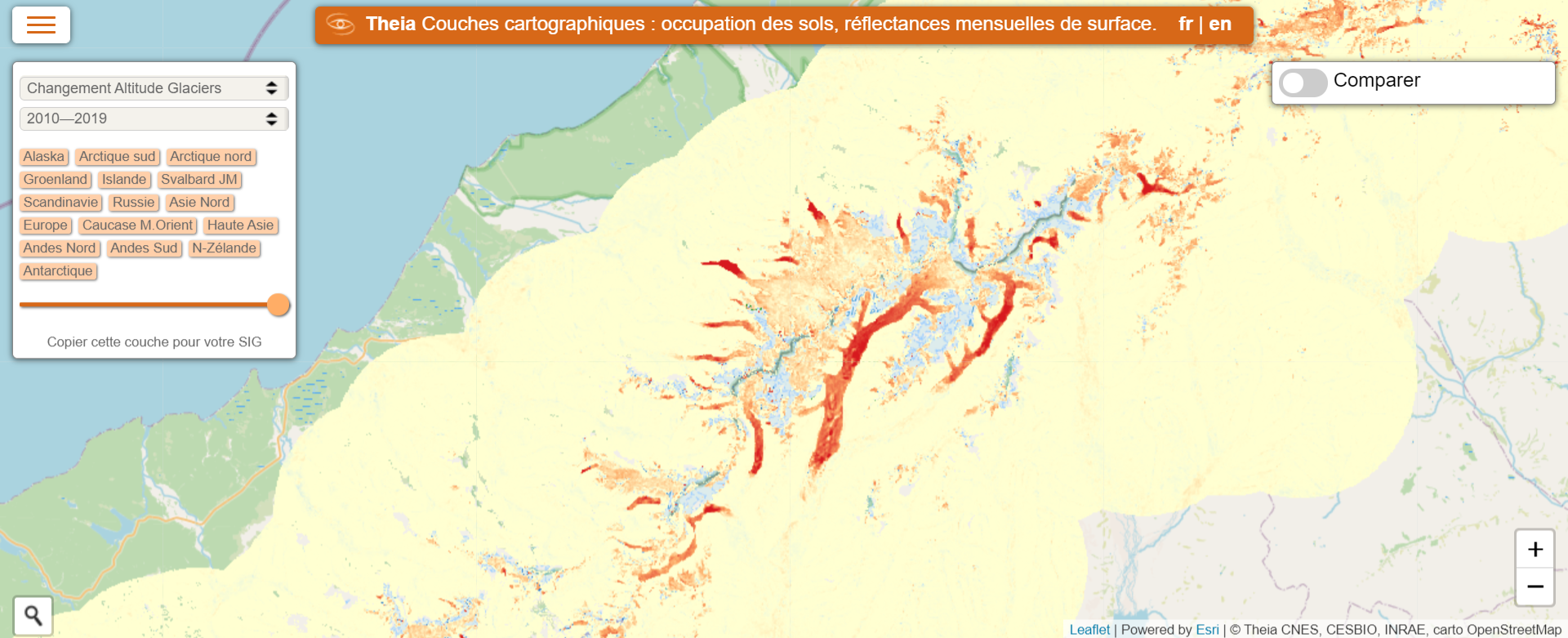
Monitoring 700,000 km² of the world’s glaciers
The 700,000 km² of glaciers on Earth (excluding the Greenland and Antarctic ice caps) are shrinking rapidly, altering regional hydrology, raising global sea level and elevating natural hazards. Yet, owing to the scarcity of constrained mass loss observations, glacier evolution is known only partially, as a geographic and temporal patchwork.
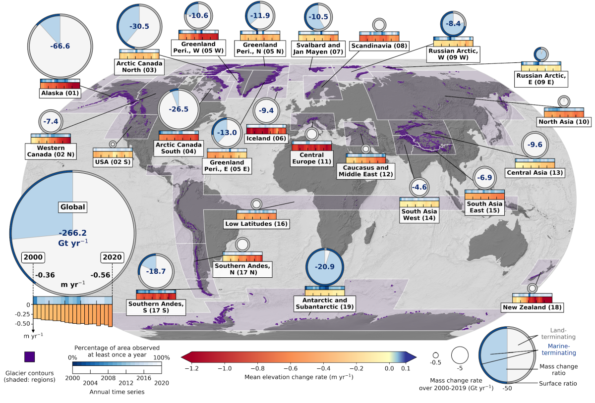
In a study recently published in Nature using previously largely untapped satellite archives, an international team led by LEGOS glaciologists and associated with Theia Glaciers SEC has mapped the elevation changes of all the world’s glaciers at high spatial and temporal resolution, revealing their accelerated and contrasting mass losses between 2000 and 2019. These data are now available in two ways on Theia: as a 1°x1° tile visualization or as a global bulk download.
The validation of this new dataset was carried out using data from the ICESat and Ice-bridge missions, but also thanks to high-resolution elevation difference maps deduced, among others, from Pleiades and SPOT6-7 images obtained in the framework of the DINAMIS programme. The whole project has been funded for almost 10 years by French Space agency CNES through its TOSCA programme.
Monitoring Glaciers and their evolution by region
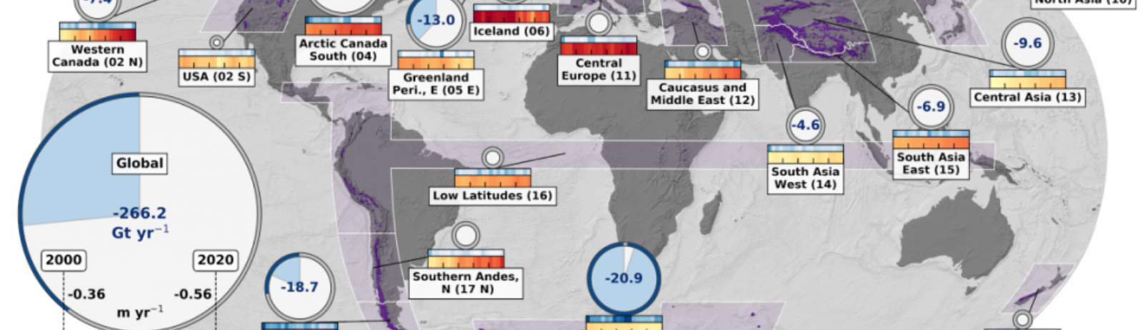
The product Rate of Glaciers Elevation Changes from 2000 to 2019 allows researchers to estimate glacier mass change during 2000–2019: at world scale, glaciers lost a mass of 267 ± 16 gigatonnes per year, equivalent to 21 ± 3 per cent of the observed sea-level rise. The product identifies and documents as well a mass loss acceleration of 48 ± 16 gigatonnes per year per decade, explaining 6 to 19 per cent of the observed acceleration of sea-level rise. Particularly, thinning rates of glaciers outside ice sheet peripheries doubled over the past two decades. Glaciers currently lose more mass, and at similar or larger acceleration rates, than the Greenland or Antarctic ice sheets taken separately.
Based on these new estimates, we document contrasting glacier fluctuations that agree with the decadal variability in precipitation and temperature. These include a North Atlantic anomaly of decelerated mass loss, a strongly accelerated loss from north-western American glaciers, and the apparent end of the Karakoram anomaly of mass gain.
These highly resolved estimates should advance the understanding of drivers that govern the distribution of glacier change, and to extend our capabilities of predicting these changes at all scales. Predictions robustly benchmarked against observations are critically needed to design adaptive policies for the local- and regional-scale management of water resources and cryospheric risks, as well as for the global-scale mitigation of sea-level rise.
Contact

Romain Hugonnnet
LEGOS
ResearchGate
@R.Hugonnet

Étienne Berthier
LEGOS
@e.berthier
ResearchGate
To go further
Hugonnet, R., McNabb, R., Berthier, E., Menounos, B., Nuth, C., Girod, L., Farinotti, D., Huss, M., Dussaillant, I., Brun, F., and Kääb, A.: Accelerated global glacier mass loss in the early twenty-first century, Nature, 2021. DOI : 10.1038/s41586-021-03436-z