Orfeo Toolbox User Days 2016
Orfeo Toolbox team is happy to announce the second edition of the OTB User Days to be held from 7 to 9 June 2016 in Toulouse.
Agenda
Orfeo Toolbox team is happy to announce the second edition of the OTB User Days to be held from 7 to 9 June 2016 in Toulouse.

Infrastructure
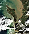
The SPOT5 (Take5) project just released a new version of all SPOT5 (Take5) L2A data to account for several small issues encountered during the first processing.
News
The Theia Muscate production center distributes new level 2A Landsat 8 products acquired from March 1st to 30th 2016 over France.
News
The Theia Muscate production center distributes new level 2A Landsat 8 products acquired from February 1st to 29h 2016 over France.

Agenda
A call for abstract is opened in the framework of the International Conference on Water, Energy & Climate Change (WECC-2016) which be held in Marrakech (Morocco) from the 1st to the 4th of June, 2016.
News
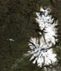
The snow-covered surface Scientific Expertise Centres (CES) processed a first Sentinel-2A image acquired in the Pyrenees with its snow mask.
News
The Theia Muscate production center distributes new level 2A Landsat 8 products acquired from January 1st to 31th 2016 over France.

Agenda
The dead-line for call for abstracts for the conference Spatial Accuracy 2016 is extended to the 15th of February 2016.
News
The Theia Muscate production center distributes new level 2A Landsat 8 products acquired from December 16th to 30h 2015 over France.
News
The Theia Muscate production center distributes new level 2A Landsat 8 products acquired from December 1st to 15th 2015 over France.
News
The Theia Muscate production center distributes new level 2A Landsat 8 products acquired from November 16 to 30th 2015 over France.
News
The Theia Land Data Centre new bulletin is available in English.