Just released: Provisional Landsat Aquatic Reflectance Product
The EROS Science Processing Architecture (ESPA) on behalf of the USGS Landsat program and USGS EROS has announced the release of a new Landsat 8 Provisional Aquatic Reflectance product. This provisional science product aims to contributie to aquatic science and environmental monitoring capabilities for aquatic ecosystems, especially in coastal environments and inland water bodies.
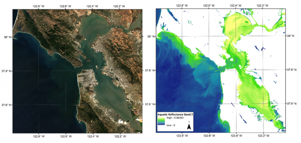
The Landsat 8 Provisional Aquatic Reflectance product is derived from Landsat 8 Level-1 (L1) reflective bands over water bodies. Top of Atmosphere (TOA) reflectance and auxiliary atmospheric data are input to an atmospheric correction algorithm to retrieve the water-leaving radiance at visible wavelengths. The water-leaving radiances are then normalized by downwelling solar irradiance to remove the remaining effects of solar orientation and atmospheric attenuation to produce spectral remote sensing reflectance (Rrs) for visible bands. Finally, the Rrs visible bands are normalized by the Bidirectional Reflectance Distribution Function (BRDF) of a perfectly reflecting Lambertian surface (multiplied by π) to produce dimensionless Aquatic Reflectance. The atmospheric correction algorithm used to generate Landsat 8 Provisional Aquatic Reflectance products is based on the Sea-viewing Wide Field-of-View Sensor (SeaWiFS) Data Analysis System (SeaDAS) package distributed by NASA’s Ocean Biology Processing Group.
Landsat 8 Provisional Aquatic Reflectance products are generated at 30-meter spatial resolution. The default projection system for Landsat science products is Universal Transverse Mercator (UTM), but other projection systems such as Albers Equal Area (AEA), Sinusoidal, Geographic, and Polar Stereographic (PS) are available through the ESPA on-demand interface as a customized service.
More information on the product
https://www.usgs.gov/land-resources/nli/landsat/landsat-provisional-aquatic-reflectance