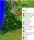
First prototype land cover map
The Scientific Expertise Center on Land Cover provides its first prototype products, land cover Maps automatically generated.
The first products span over one third of France, and have 15 to 20 classes according to the versions. The first prototype products were computed using the Landsat 8 Level 2A data from Theia, pending availability of a whole year of Sentinel-2 data.
Thanks to its high resolution observations, Sentinel-2 should enable an automatic generation of land cover maps at country scale. Based on a several years of research at Cesbio, the project to automatically produce land cover maps generated annually at a decameter resolution over the whole France is gaining momentum.
More information on www.cesbio.ups-tlse.fr
More information: Land cover mapLand cover CESLandsatSentinel-2