Mapping irrigation in Catalonia
Irrigation, nowadays, plays a significant role in agricultural production in order to meet the global food requirement. In fact, irrigated agriculture accounts now for more than 80% of water withdrawn from rivers, lakes, and groundwater aquifers being, then, the principal consumer of fresh water resources. Due to this fact, a better management of irrigation policies is required to deal with the high demand of food with the increase in the global population. Thus, accurate information on the irrigated area extent are essential to manage water resources or evaluate irrigation water requirements. Unfortunately, the extent and distribution of irrigated areas remain indefinite and the large-scale mapping of such property remains a challenge for modern remote sensing analysis.
Mapping Irrigation at large scale
Using remote sensing data (radar and optical), several efforts have been made to map irrigated areas at different scales. The data availability of the recent Sentinel-1 (radar) and Sentinel-2 (optical) constellations offers an effective tool for large-scale irrigation area mapping due to their high revisit period (5 to 6 days) and their high temporal resolution (10m).
In Catalonia, crop production is mostly linked to intensive irrigation practices. Thus, irrigation in the region is developing rapidly, as one of the central element in the modernization process. A third of cultivated area is irrigated representing about two third of the economic value of crop production.
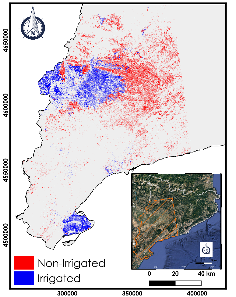
In the context of mapping irrigated areas, an irrigation map of Catalonia has been realized by applying the Convolutional Neural Network (CNN) on the Sentinel-1 multi-temporal data for the year 2018. The classification of irrigated/non-irrigated plots have been realized over the winter and summer agricultural plots. The SIGPAC Geographical Information System for Agricultural Parcels) database has been used to define the plot limits, the land cover type and the irrigation information for training the irrigation classification model. The irrigation map of Catalonia is available via the Theia website. It is delivered in two formats (raster and vector). The Sentinel-1 time series used covers the period between September 2017 and December 2018. The precision of the obtained map reaches 94% when compared to the terrain database of the SIGPAC data.

Nicolas Baghdadi
INRAE | Tetis
ResearchGate
Contributions

Hassan Bazzi
INRAE | Tetis
ResearchGate

Dino Ienco
INRAE | Tetis
ResearchGate
Contributions
Go further
Read the New Theia Bulletin
>>> Read on-line on Calaméo