Theia 9th bulletin
The Theia Land Data Services Centre new bulletin is available in English.
The Theia Land Data Services Centre new bulletin is available in English.
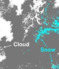
Maps of snow cover area at 20m resolution generated from Sentinel-2 observations are available every 5 days on theia.cnes.fr.
Series of books on QGIS in remote sensing has just been published with ISTE-Elsevier editions.
The Theia Land Data Services Centre new bulletin is available in English.
The Theia Land Data Centre new bulletin is available in English.
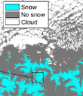
Theia releases since June 2017 a new 20 m resolution product which indicates the snow presence or absence on the land surface every fifth day if there is no cloud.
A call for papers is open until the 30th of September 2017 for the Remote Sensing Journal « Special Issue: Science and Applications with Sentinel-2 ».
« Sourcebook of Methods and Procedures for Monitoring Essential Biodiversity Variables in Tropical Forests with Remote Sensing » published by Global Observation of Forest Cover and Land Dynamics (GOFC-GOLD) is available for download.
Postel has associated R&D and services from 2001 to 2008 to describe the soil and vegetation from Earth Observation satellite data, at regional and global scales.