The first images Landsat 8 corrected from atmospheric effects are available

The first Landsat 8 images corrected from atmospheric effects are available here.

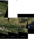
These are Landsat 8 images acquired over France between April and December 2013. The images have been processed by the MUSCATE workshop at CNES using a prototype of Level 2A processing line, MACCS, conceived and developed at CESBIO.

More information: 

More news

AlTiS-NG GUI with Jason-2 mission on the Komadugu river, Niger

AlTiS-NG: A new tool for analysing altimetry data in hydrology

Discover AlTiS-NG, THEIA new hydrological altimetry software presented on Tuesday 24 June on the Data Terra stand at the LPS.

Data Terra, a major data player, awaits you at the Living Planet Symposium 2025

Join Data Terra at the heart of innovation at the Living Planet Symposium 2025! From June 23 to 27 in Vienna.

Engineer in remote sensing applied to monitoring tropical forest ecosystems

The INRAE offers a remote-sensing engineer position in TETIS laboratory, Montpellier, France.

Search