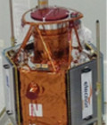
Sentinel-1 first images

Launched on 3 April, ESA’s Sentinel-1A satellite has delivered its first radar images of Earth on 12 April 2014.

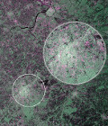
They offer a tantalising glimpse of the kind of operational imagery that this new mission will provide for Europe’s ambitious Copernicus environmental monitoring programme.

Rather aptly, the first image shows Brussels in Belgium, just one day after the satellite was put into its operational attitude, and demonstrates the potential of Sentinel-1A’s radar vision.

Images to discover on ESA website.


More information: 

More news

Two THEIA LiDAR tools for forest monitoring

On this International Day of Forests, for which innovation has a major role to play in 2024, we are highlighting two tools dedicated to the management of aerial LiDAR data […]

SWOT data that exceeds expectations

The SWOT space mission was launched at the end of 2022 by CNES and NASA to document the water masses of the entire planet – oceans and continental waters. Data […]

Albédo Sentinel 2 THEIA pur l'Île-de-France, juin 2022

Measuring the albedo of mainland France from Sentinel-2

THEIA’s Albedo team has developed a method for calculating high-resolution (HR) albedo using Sentinel-2 data. The method has already been used as part of the Copernicus Global Land Service program, […]

Search