Publications

NEW PRODUCTION AND DISTRIBUTION MEANS FOR THE CNES THEIA CDS

The CDS THEIA of CNES is opening new centers to improve access to and dissemination of Earth observation data.

03.02.2025

Resumption of CNES THEIA CDS Production

The CDS THEIA Team at CNES is pleased to announce the resumption of value-added product production starting December 12, 2024, on its new production center. This production resumption, effective from […]

19.12.2024

GEOV2-AVHRR: updated and consolidated plant data

The GEOV2-AVHRR collection includes the 2022 version of 3 essential vegetation variables (LAI, FAPAR, FCOVER). The whole data processing has also been updated.

17.12.2024

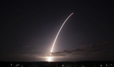
Welcome to Sentinel-2C, but why not keep Sentinel-2A operational too?

The Sentinel-2C satellite was launched by ESA and the Copernicus programme on 4 September 2024 on a VEGA launcher. As soon as it is operational, nominally following an estimated 3-month […]

06.09.2024

The 2nd Workshop dedicated to high-resolution thermal observation gets underway

Save already the date for the coming 2nd French-Indian Workshp dedicated to HR thermal observation.

01.08.2024

clASpy_T : a 3D point cloud classification tool for estuary monitoring

The THEIA portfolio of Lidar data processing tools has been extended with a new software tool for creating 3D point cloud classification models using machine learning: cLASpy_T cLASpy_T aims to […]

04.06.2024

Two THEIA LiDAR tools for forest monitoring

On this International Day of Forests, for which innovation has a major role to play in 2024, we are highlighting two tools dedicated to the management of aerial LiDAR data […]

21.03.2024

SWOT data that exceeds expectations

The SWOT space mission was launched at the end of 2022 by CNES and NASA to document the water masses of the entire planet – oceans and continental waters. Data […]

07.03.2024

Albédo Sentinel 2 THEIA pur l'Île-de-France, juin 2022

Measuring the albedo of mainland France from Sentinel-2

THEIA’s Albedo team has developed a method for calculating high-resolution (HR) albedo using Sentinel-2 data. The method has already been used as part of the Copernicus Global Land Service program, […]

06.03.2024

Search