SWOT data that exceeds expectations
The SWOT space mission was launched at the end of 2022 by CNES and NASA to document the water masses of the entire planet – oceans and continental waters. Data from this mission covering virtually the entire Earth (78°S-78°N) are now available, starting on July 26, 2023. The scientific teams are now beginning to have the necessary hindsight to assess data quality.
An article on this subject was published on February 21, 2024 in Geophysical Research Letters : The Surface Water and Ocean Topography Mission: A Breakthrough in Radar Remote Sensing of the Ocean and Land Surface Water
In particular, the article details the quality of the first data available on two major topics for continental surfaces: the assessment of lake stocks and river flows, and the monitoring of coastal water levels to measure the local impact of rising sea levels.
In both cases, SWOT data are proving to be unprecedentedly accurate for monitoring these major issues. Very small variations over very small areas, even more precise than the initial prescriptions or other existing tools, are thus observable.
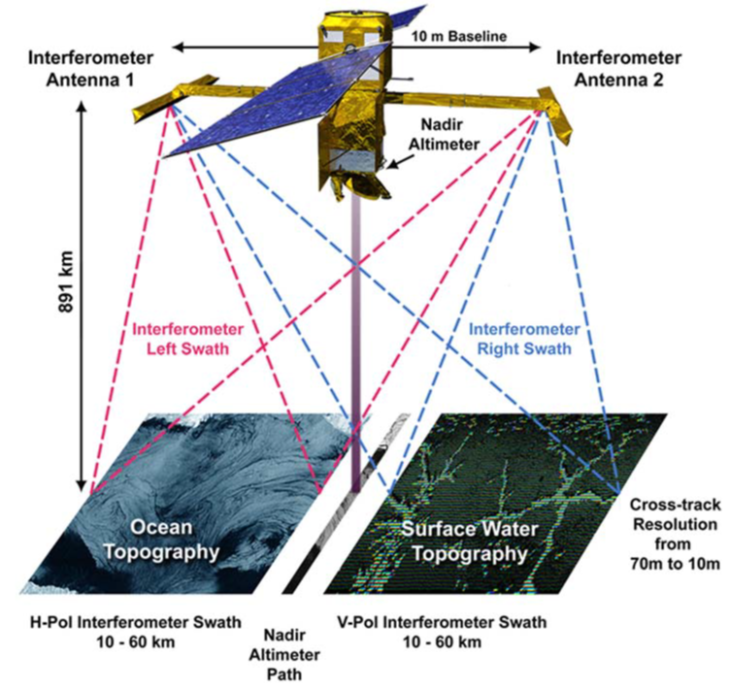
They testify to the precision of the on-board KaRIN radar interferometer. This innovative device takes measurements in two 50 km bands, with a 21-day revisit. The two measurement bands are located on either side of a 20 km band, in the middle of which the conventional nadir measurement is taken.
What SWOT promises for lake heights and river flows
SWOT data will broaden the possibilities for monitoring the world’s lakes and rivers – a process already well underway with THEIA’s Hydroweb product. The initial results make it possible to monitor smaller rivers and lakes, which have been difficult to observe until now. They also open up the possibility of monitoring flooding events in places that have not been instrumented to date.
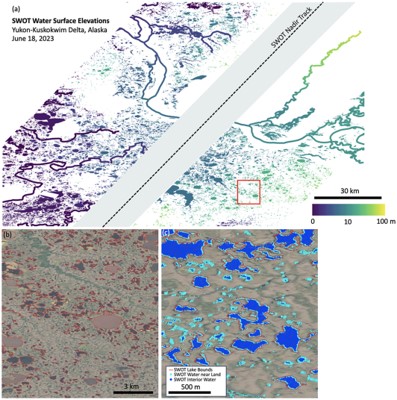
To take just one of the examples developed in the article, the SWOT results for observation of the Canadian Yukon Delta opposite illustrate these renewed capabilities.
Estimated water surface elevations (a) are accurate and consistent with other measurements. Lake boundaries are consistent with optical observations (b). New water objects, smaller than a ha on the surface, are clearly documented (c).
These SWOT hydrological surface elevation data will be made available on the CNES|THEIA hydroweb.next platform from March 6, 2024. Initially, only data processed since January 2024 will be available. Other data corresponding to earlier observations will be available by the end of the month. We’ll be coming back to you regularly to give you more details. Meanwhile, you can already read below the release note on available SWOT products, published on March 6.