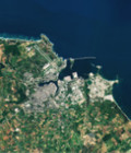
New Sentinel-2A data over Morocco

One year of Sentinel-2A data at Level 2A above a large region of Morocco, from Ouarzazate to Casablanca, are available from theia.cnes.fr.

Level 2A products provide surface reflectances corrected from atmospheric effects, with a high quality cloud mask.

For more information, see cesbio.ups-tlse.fr/multitemp.

More information: Sentinel-2

More news

clASpy_T : a 3D point cloud classification tool for estuary monitoring

The THEIA portfolio of Lidar data processing tools has been extended with a new software tool for creating 3D point cloud classification models using machine learning: cLASpy_T cLASpy_T aims to […]

[PhD] Spatio-temporal dynamics of suspended particulate matter in the estuary/coastal sea continuum

Thesis project aiming to integrate and interact high-frequency in situ data (COAST-HF, SYNAPSES) with water color satellite data (Sentinel 2/3 – Landsat – MODIS) to enhance our understanding of the land-sea interface.

Two THEIA LiDAR tools for forest monitoring

On this International Day of Forests, for which innovation has a major role to play in 2024, we are highlighting two tools dedicated to the management of aerial LiDAR data […]

Search