China launches new remote sensing satellite

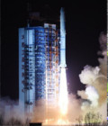
China launched the Yaogan-23 remote sensing satellite into scheduled orbit on 15th november 2014 from Taiyuan Satellite Launch Center.

The satellite will mainly be used for scientific experiments, natural resource surveys, crop yield estimates and disaster relief.

It was carried by a Long March-2C rocket, marking the 198th mission for the Long March rocket family. 

More information: Data access

More news

[PhD] Spatio-temporal dynamics of suspended particulate matter in the estuary/coastal sea continuum

Thesis project aiming to integrate and interact high-frequency in situ data (COAST-HF, SYNAPSES) with water color satellite data (Sentinel 2/3 – Landsat – MODIS) to enhance our understanding of the land-sea interface.

Two THEIA LiDAR tools for forest monitoring

On this International Day of Forests, for which innovation has a major role to play in 2024, we are highlighting two tools dedicated to the management of aerial LiDAR data […]

SWOT data that exceeds expectations

The SWOT space mission was launched at the end of 2022 by CNES and NASA to document the water masses of the entire planet – oceans and continental waters. Data […]

Search