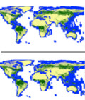
Global 25m-resolution mosaic and forest/non-forest map
Japan Aerospace Exploration Agency, JAXA, has produced the 4 year-25m spacing global PALSAR mosaics, that Advanced Land Observing Satellite (ALOS)/ Phased array Type L-band SAR (PALSAR) collected globally from 2007 to 2010 using the accurate SAR processing.
JAXA also produced the first version of the 10m spaced global forest/non-forest map experimentally 2010. This time, we have produced the new forest/non-forest map (FNF-map) (validation version) by precisely evaluating the mosaic data regionally and temporally and comparing with the optical data (Google Earth images) and ground truth data. Fig. 1 shows the FNF map of 2007, 2008, 2009, and 2010. FNF-map is the important geophysical information on investigating the temporal forest land change, terrestrial causes on global warming, and proceeding the activity on Reducing the Emission from Deforestation and forest Degradation plus (REDD+).
More information on Alos