First Sentinel-2 snow map in the Pyrenees
The snow-covered surface Scientific Expertise Centres (CES) processed a first Sentinel-2A image acquired in the Pyrenees with its snow mask.
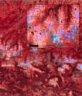
After tests with SPOT-4 Take-5 and Landsat-8 series, the simple but robust method to map the snow cover from Sentinel-2-like level 2A products was tested with the Sentinel-2A image acquired on 06-July-2015 in the Pyrenees. This image was produced at level 2A using the MACCS processor.
The snow mask from Sentinel-2 images is calculated at 20 m resolution after resampling the green and red bands that are originally at 10 m resolution while the NIR band is at 20 m. To make sure everything went well, the snow mask was controled by superposing the mask boundaries on a false color composite and an aerial orthophoto.
Images of the results on the multitemp blog
More information: Snow-covered surface CESSnow / IceSentinel-2