Access
Description
More and more sustainable development programs are integrating a landscape approach to improve land management (Tonneau et al., 2020.). The Land Units (LUs), on which most of these programs are based, are intended to provide a spatial framework for management and planning actions: subsidies for agriculture, protection of natural areas, implementation of agro-ecological practices, etc.
However, to date there is no consensus on the delineation of these LUs because the synthesis of information from various sources can be subject to different interpretations, or because of the subjectivity of the maps produced «by expert opinion» makes them difficult to transfer to managers. We therefore propose an original «objective» approach based essentially on Earth Observation data.
The spatial (global coverage and completeness), temporal (archive depth, seasonal information) and physical (measurements comparable in time and space) characteristics of Earth Observation data make it unique for mapping LUs. Indeed, the temporal satellite signal is characteristic of surface conditions, the latter depending on climate, soil, topography and human activities which are also the main determinants of landscapes. The semi-automatic delineation of landscape units from time series of vegetation index images (via the principal components of the time series, and possibly a texture index) is a robust, generic (a statistical test is used to select the segmentation scale) and easily transferable approach.
Brazil, Burkina Faso, France
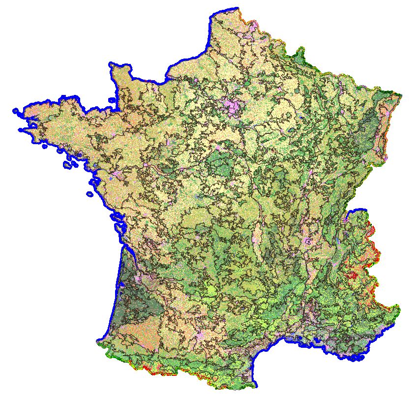
This approach has been tested at the scale of France (Bisquert et al., 2015), Burkina Faso (Bellon, 2018) and the Tocantins State in Brazil (Bellon et al., 2017) using MODIS time series (NDVI or EVI). In the case of France (Bisquert et al., 2017) and the Tocantins (Bellon et al., 2017), the relevance of these units in terms of environmental and human variables has been demonstrated.
The development and provision of a time series processing chain (MODIS; Sentinel-2) for an automatic delineation of landscape units is planned within the framework of the CNES APR TOSCA project run by Theia Landscape SEC (2021-2023)
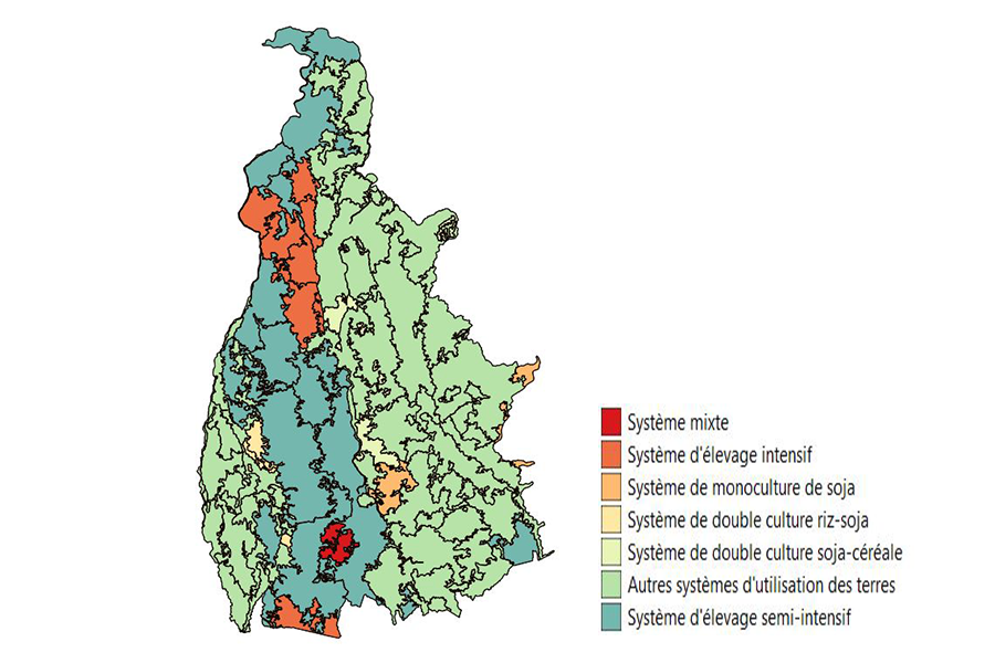
Delimitation of Land Units for the State of Mato Grosso (Brazil) extracted from MODIS NDVI time series for the crop year 2013-2014; labelling of units as agricultural systems.
Reference
Bellón B., Bégué A., Lo Seen D., de Almeida C.A. and M. Simões, 2017. A remote sensing approach for regional-scale mapping of agricultural land-use systems based on NDVI time series. Remote Sensing, 9:600. http://dx.doi.org/10.3390/rs9060600
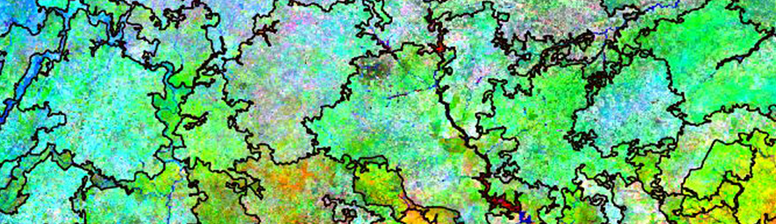
80 Land Units for Burkina Faso (Background used: Coloured composition of the Main Components 2, 3 and 4 of the 2016 MODIS NDVI time series)
Reference
Bellon Beatriz (2018). « L’agronomie des paysages des Suds : analyse régionale par télédétection de la sécurité alimentaire et des risques environnementaux liés à l’agriculture ». Thèse de Doctorat de AgroParisTech, Montpellier (FR), soutenue le 24 mai 2018 à Montpellier (FR), 192 p. + annexes.
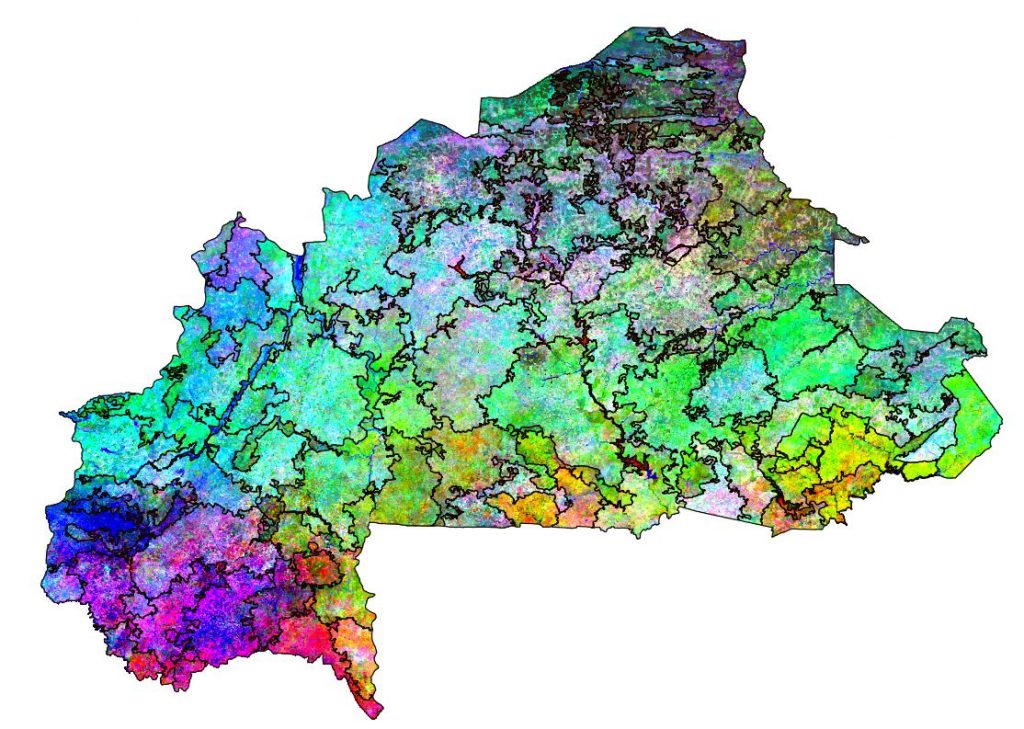
300 Land Units derived from MODIS EVI time series between 2007 and 2011 (Background used: Theia Land Cover Map 2015).
References
Bisquert M., Bégué A., Deshayes M., Ducrot D., 2017. Environmental evaluation of MODIS-derived land units. GIScience & Remote Sensing (TGRS), 54:64-77.
Bisquert M., Bégué A., Deshayes M., 2015. Object-based delineation of homogeneous landscape units at regional scale based on MODIS time series. International Journal of Applied Earth Observation & Geoinformation, 37:72-82.
Contact

Agnès Bégué
CIRAD | TETIS
@A.Begue
Reference
Tonneau Jean-Philippe, Bouvet Jean-Marc, Burnod Perrine, Herimandimby Hasina, Raharinjanahary Holy, Queste Jérôme, Rakotondrainibe J.H., Ratsima Arimino Toky, Labeyrie Vanesse. 2020. Guide pour l’élaboration d’un plan d’aménagement et de gestion durable des paysages (PAGDP). Montpellier : CIRAD. 3 tomes.
Demander une copie sur Agritop