Land cover Theia product update
Like every year at this time, you’re invited to discover the new version of the OSO product, from the S.E.C Land cover. The 2022 version was released a few days ago!
New and improved features
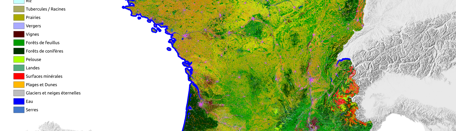
It’s very similar to the product you’re used to looking at or using for your work. Accuracy is also close to that of previous versions : the agricultural classes, 7 in all, perform best, as do the forestry, water and permanent snow classes. We’re still encountering the same difficulties in detecting certain classes, such as those describing natural environments (lawns and heaths) and urban environments, as well as orchards and vineyards. This is hardly surprising, since we haven’t yet done anything to improve them.
Greenhouses are a new addition to the Land cover class family this year! Using the BD TOPO, we have experimented with the prediction of greenhouses on a national scale. The detection performances obtained are correct. We don’t know what correct means, but we obtained an overall performance of 0.8. As expected, the white colour of greenhouses blends in with the artificial surfaces of industrial and commercial zones, so we’re seeing a tendency for this class to be over-classified. You tell us! As usual, we’d love to hear from you!
Coming soon
This year, we’d also like to give you a present! In order to harmonise the nomenclature between all the versions, we are going to reprocess the old 2016 and 2017 vintages, which only had two agricultural classes (summer and winter crops). Scheduled for release in autumn 2023.
Acknowledgements
We would like to thank the production team at CNES who, as every year, do their utmost to produce Land cover as quickly as possible, with a great deal of patience. We would like to thank the ASP, without which the prediction of agricultural classes would be impossible with this level of quality. Finally, thanks to the IOTA² team for improving and maintaining the chain.
Contacts

Vincent Thierion
INRAE | CESBIO
@V.Thierion
Contributions FR

Silvia Valero
CESBIO
Google Scholar
@S.Valero
Arthur Vincent
CS-Group
Main developer of the Iota² chain