Thermal Infrared: Understanding Practices and Assessing Needs
Theia Surface Temperature and Emissivity Scientific Expertise Centre Surface (SEC) aims to federate national laboratories working on the estimation of Land Surface Temperature (LST) and Land Surface Emissivity (LSE) from available thermal infrared data to improve the accuracy of these products and to offer them to the community. In this framework, a survey was conducted at the beginning of 2020 to better identify user needs, the difficulties encountered and to specify which improvements should be made in order to provide adapted and better quality products.
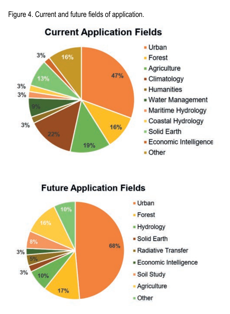
A small TIR community
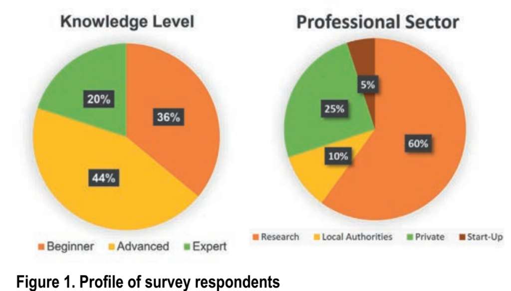
41 people with varying levels of knowledge of thermal infrared (TIR) data and from different professional sectors responded to the survey (Figure 1). Perhaps as a result of a bias related to the survey’s dissemination network, academic research is the most represented sector (60%) and urban environment is the predominant field of application (47%). However, the range of uses mentioned by the participants is very wide. It covers both very upstream research activities such as improving estimates and developing processing chains, as well as more downstream or even commercial applications. The responses highlight the great diversity of applications and confirm the interest and need for TIR data and products in all sectors.
Nearly 80% of the respondents are already TIR data users : mainly satellite data downloaded online and, to a lesser extent, airborne and ground data. Unmanned aerial vehicle (UAV) data are still seldom used.
Furthermore, it is common for one person to use several types of data. Although Top Of Atmosphere (TOA) radiance and LST are the most popular products, others with different processing levels are also significantly used. 70% of the users reported performing post-processing on the data.
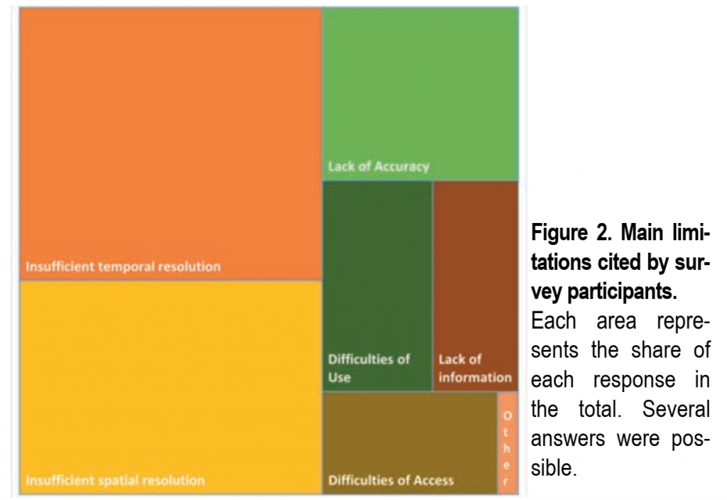
The main limitations encountered when using TIR products are insufficient spatial and temporal resolutions, as well as the lack of accuracy, information and validation of the estimates. These limitations are also mentioned by future users, in addition to the difficulties of access and use. (Figure 2)
Identifying user expectations
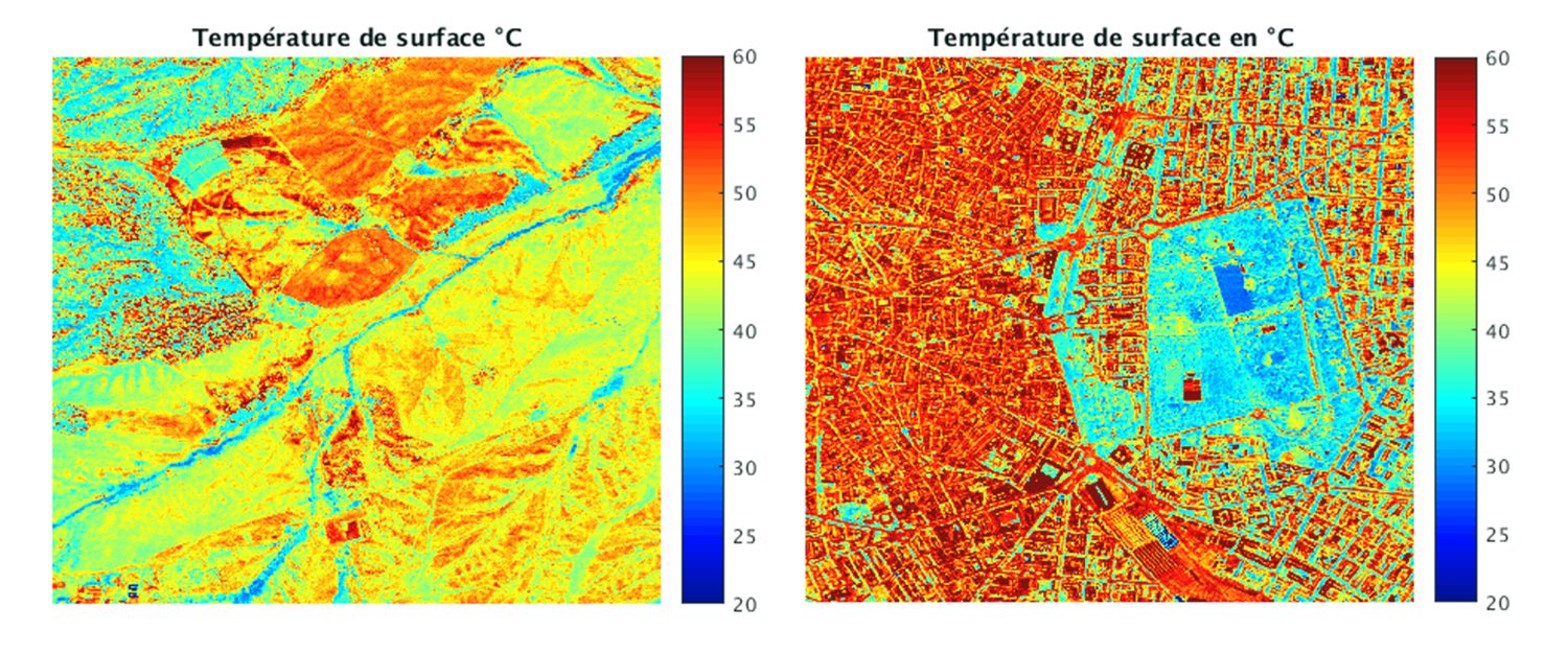
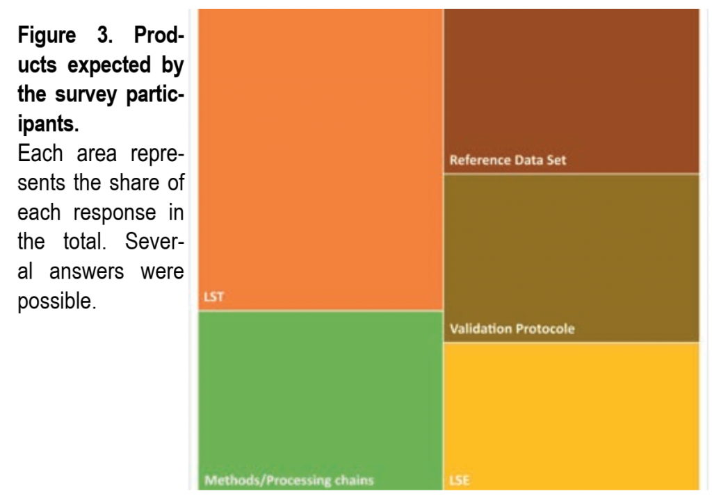
The responses gathered have enabled a better understanding of user expectations and the expression of specific needs for future TIR products. (Figure 3) Although LST is the most sought-after parameter, the demand for LSE maps, methods and processing chains, validation protocols and reference datasets is also significant. Preferences expressed for the specification of the LST/LSE products are a spatial resolution of less than 50 m and a weekly, daily or even hourly temporal resolution with local or regional coverage.
However, it should be pointed out that it is very unlikely that it will be possible to obtain LST deca-metric maps at hourly time steps from satellite data in the near future. The large number of applications on urban environment explains such demand for fine spatial resolution, but other fields of applications are also interested (agriculture and forestry in particular). Concerning the accuracy of future products, half of the respondents expressed an opinion for LST, the majority of which recommending an accuracy of 1 K. The importance of the relative error for this parameter, which should ideally be around 0.1 K, was also mentioned. For the LSE, only 20% responded indicating an accuracy between 0.5 and 1%.
Overall, these results underline the large gap between expectations and available TIR products.
Future TIR satellite missions such as TRISHNA (Read Theia Bulletin n°13), LSTM or HyspIRI, could potentially address this gap, involving the preparation of future products and the development of data disaggregation and fusion techniques to achieve expected accuracies and resolutions.
A roadmap for the development of adapted products
In conclusion, there is a strong demand for LST and, to a lesser extent, LSE products at fine spatial and temporal resolutions for a wide variety of applications in different sectors. To meet this demand, it is essential to develop techniques to estimate and disaggregate TIR data, especially for future TIR missions. It is also essential to work on the improvement of the accuracy of the retrieved parameters and to clearly evaluate and document the products provided. This translates into in-depth work on improving retrieval methods, particularly in heterogeneous environments, and, above all, on providing protocols and data to carry out reliable validations. In this context, acquisitions by UAVs and the processing of related data could be exploited further.
In addition, there are already several thermal datasets available on which to rely and a willingness from the users to share and pool the efforts. A final point highlighted by this survey is the importance of informing and raising awareness among users regarding the specificities of TIR data in order to facilitate their understanding and use. All these observations are fully in line with the role of the SEC following four main axes: Products, Improvements, Awareness raising, Federation.
Contacts

Laure Roupioz
Ingénieure de recherche à l’Onera
@L.Roupioz

Aurélie Michel
Onera | DOTA
ResearchGate