Presentation
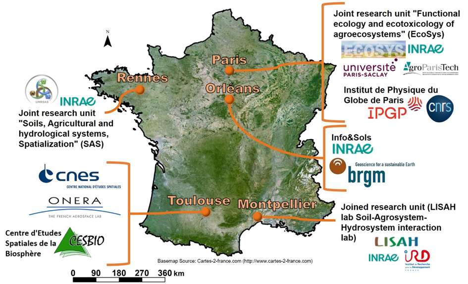
THEIA group of experts in Digital Soil Mapping brings together French national organizations involved in soil mapping by statistical modeling (Digital Soil Mapping). Theia DSM SEC gathers the following teams:
- UMR ECOSYS: Joint Research Unit EcoSys (Functional ecology and ecotoxicology of agroecosystems) https://www6.versailles-grignon.inrae.fr/ecosys_eng/
- UMR SAS (Soil, Agro- and hydro-systems, Spatialisation) https://www6.rennes.inrae.fr/umrsas_eng/
- CNES (Centre national d’études spatiales) https://cnes.fr/en
- ONERA (The French aerospace lab) https://www.onera.fr/en
- IPGP (Institut de Physique du Globe de Paris) http://www.ipgp.fr/en
- BRGM (Bureau de Recherches Géologiques et Minières (French geological survey)) https://www.brgm.fr/en
- Info&Sols (INRAE)
- UMR LISAH (Laboratoire d’Etude des Interactions entre Sol-Agrosystème-Hydrosystème (Soil-Agrosystem-Hydrosystem interaction lab)) https://www.umr-lisah.fr/?q=en
GlobalSoilMap, the product resulting from THEIA group of experts in Digital Soil Mapping, has a resolution from 30 to 100 m and covers France and smaller French territories (regions, watersheds).
The data used are multispectral and superspectral data (Sentinel 2), soil data, digital elevation models (DEM), climate and lithological data, hyperspectral data (EnMAP, HYPXIM) and airborne gamma-radiometric data.
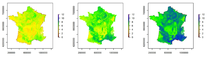
An example of a GlobalSoilMap France product. Soil pH prediction images (5-15 cm); in the centre modal value, left and right lower and upper bounds of the 90% confidence interval respectively.
Schedule:
- 2016: Building and testing of the algorithm incubator GlobalSoilMap in the pilot regions: Centre, Languedoc-Roussillon, etc.
- 2017-2018: GlobalSoilMap coverage for all of France + methodology guide
- 2020-2023: Ongoing on-line availability of national GlobalSoilMap products at 90-m resolution
- 2021-2023: Ongoing on-line availability of improved maps for some French regions.
- 2021-2023: Availability of Digital Educational Resources
Contact

Anne Richer-de-Forges
INRAE | Info&Sols
ResearchGate
Contributions FR
References
All publications can be found on our blog
https://cartograph-e.hub.inrae.fr/publications
Links
At national level

sols-et-territoires.org
https://www.openig.org/actualites/lancement-officiel-du-projet-feder-terra-occitania
At international level
isric.org
gladsoilmap-consortium

opengeohub.org
data.csiro.au
pedometrics.org/
www.iuss.org